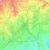
Smith County topographic map
Click on the map to display elevation.
About this map
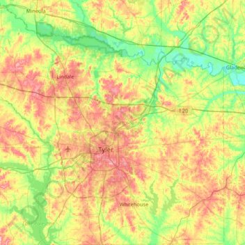
Name: Smith County topographic map, elevation, terrain.
Location: Smith County, Texas, United States (32.13507 -95.59463 32.68707 -94.98537)
Average elevation: 131 m
Minimum elevation: 78 m
Maximum elevation: 210 m
Other topographic maps
Click on a map to view its topography, its elevation and its terrain.

Enchanted Rock
United States > Texas > Llano County
Enchanted Rock is a pink granite mountain located in the Llano Uplift about 17 miles (27 km) north of Fredericksburg, Texas and 24 miles (39 km) south of Llano, Texas, United States. Enchanted Rock State Natural Area, which includes Enchanted Rock and surrounding land, spans the border between Gillespie and…
Average elevation: 453 m




Belton
United States > Texas > Bell County > Belton > Belton
Belton is located 60 miles (97 km) north of Austin, 137 miles (220 km) south of Dallas, and 184 miles (296 km) west of Houston. It is near the center of Bell County at 31°3′32″N 97°27′48″W / 31.05889°N 97.46333°W / 31.05889; -97.46333 (31.058904, -97.463382). It is at the point where the…
Average elevation: 176 m


Roosevelt
United States > Texas > Lubbock County
Roosevelt is an unincorporated community in Lubbock County, Texas, United States. It sits at an elevation of 3136 feet (956 m). The community is part of the Lubbock Metropolitan Statistical Area. It mainly consists of Roosevelt High school. There is also a Baptist church here.
Average elevation: 957 m


Flint
United States > Texas > Smith County
Flint is an unincorporated community in southeastern Smith County, Texas, United States. It lies along FM 2493, south of the city of Tyler, the county seat of Smith County. Its elevation is 522 feet (159 m). Although Flint is unincorporated, it has a post office, with the ZIP code of 75762.
Average elevation: 146 m












Padre Island National Seashore
United States > Texas > Kenedy County > Corpus Christi
Average elevation: 5 m