
Thank you for supporting this site ❤️
Make a donation
Make a donation
Zevekote topographic map
Click on the map to display elevation.
Thank you for supporting this site ❤️
Make a donation
Make a donation
Zevekote
Zevekote ligt op een dekzandrug die hoger ligt dan het omringende polderlandschap. De hoogte bedraagt ongeveer 2,5 meter. Een deel van de omgeving werd verveend, waardoor laagtes ontstonden zoals het Rietbos.
Thank you for supporting this site ❤️
Make a donation
Make a donation
About this map
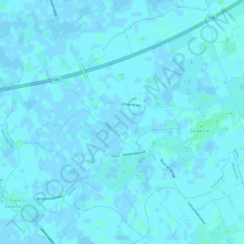
Name: Zevekote topographic map, elevation, terrain.
Location: Zevekote, Gistel, Oostende, West-Vlaanderen, België (51.12093 2.87372 51.15544 2.93153)
Average elevation: 1 m
Minimum elevation: -2 m
Maximum elevation: 5 m
Thank you for supporting this site ❤️
Make a donation
Make a donation
Other topographic maps
Click on a map to view its topography, its elevation and its terrain.
Thank you for supporting this site ❤️
Make a donation
Make a donation
Thank you for supporting this site ❤️
Make a donation
Make a donation
Thank you for supporting this site ❤️
Make a donation
Make a donation
De Meiboom
België > West-Vlaanderen > Oostende > Oudenburg > Roksem > De Meiboom
Average elevation: 6 m