Geolocate

Unteriberg topographic map

Interactive map

Click on the map to display elevation.

About this map

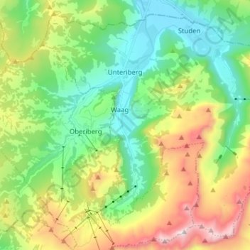
Name: Unteriberg topographic map, elevation, terrain.

Location: Unteriberg, Schwyz, Schweiz (47.00242 8.76144 47.07999 8.88890)

Average elevation: 1,346 m

Minimum elevation: 885 m

Maximum elevation: 2,269 m

Die Gemeinde Unteriberg liegt auf rund 900 m Höhe und erstreckt sich im Höch-Hund bis auf 2215 m über Meer. Der Waldanteil beträgt 35 %, der Landwirtschaft dienen 45 % der Gemeindefläche und 18 % ist unproduktiv.

Wikipedia (CC-BY-SA 3.0)

Other topographic maps

Click on a map to view its topography, its elevation and its terrain.

Ingenbohl

Schweiz > Schwyz > Schwyz

Ingenbohl, Schwyz, 6440, Schweiz

Average elevation: 674 m

Illgau

Schweiz > Schwyz > Schwyz

Illgau, Schwyz, 6434, Schweiz

Average elevation: 1,108 m

Stalden

Schweiz > Schwyz > Schwyz

Stalden, Muotathal, Schwyz, 6436, Schweiz

Average elevation: 1,067 m

Schulhaus

Schweiz > Schwyz > Schwyz > Muotathal > Ried (Muotathal)

Schulhaus, Ried (Muotathal), Muotathal, Schwyz, 6436, Schweiz

Average elevation: 865 m

Arth

Schweiz > Schwyz > Schwyz

Arth, Schwyz, Schweiz

Average elevation: 865 m

Rigi

Schweiz > Schwyz > Schwyz > Arth

Rigi, Arth, Schwyz, 6356, Schweiz

Average elevation: 1,265 m

Brunni

Schweiz > Schwyz > Schwyz

Brunni, Alpthal, Schwyz, 8849, Schweiz

Average elevation: 1,308 m

Sattel

Schweiz > Schwyz > Schwyz > Sattel

Sattel, Schwyz, 6417, Schweiz

Average elevation: 989 m

Oberiberg

Schweiz > Schwyz > Schwyz

Oberiberg, Schwyz, 8843, Schweiz

Average elevation: 1,369 m

Muotathal

Schweiz > Schwyz > Schwyz

Muotathal, Schwyz, 6436, Schweiz

Average elevation: 1,439 m