Geolocate

Tidbinbilla Mountain topographic map

Interactive map

Click on the map to display elevation.

About this map

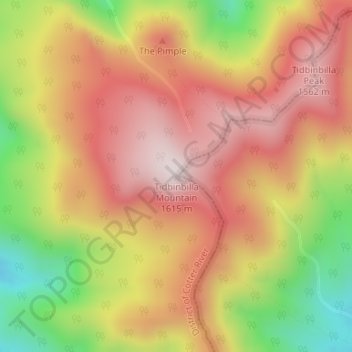
Name: Tidbinbilla Mountain topographic map, elevation, terrain.

Location: Tidbinbilla Mountain, Australian Capital Territory, Australia (-35.44553 148.86758 -35.44543 148.86768)

Average elevation: 1,309 m

Minimum elevation: 926 m

Maximum elevation: 1,588 m

Other topographic maps

Click on a map to view its topography, its elevation and its terrain.

Coolup

Australia > Western Australia

Average elevation: 22 m

Yass

Australia > New South Wales

Yass is located 280 km south-west of Sydney, on the Hume Highway, and is 59 km from Canberra. It lies at an elevation of 505 metres. The Yass River, which is a tributary of the Murrumbidgee River, flows through the town.

Average elevation: 533 m

Melbourne Water Reserve

Australia > Victoria > Melbourne

Average elevation: 127 m

Hewett

Australia > South Australia

Average elevation: 80 m

Kangaroo Valley

Australia > New South Wales

Average elevation: 320 m

Tingha

Australia > New South Wales

Average elevation: 843 m

Lower Marshes

Australia > Tasmania

Average elevation: 454 m

Port Arthur

Australia > Tasmania > Tasman

Average elevation: 153 m

Heathcote

Australia > Victoria

Average elevation: 252 m

Dover Heights

Australia > New South Wales > Sydney

Average elevation: 20 m

Blakeview

Australia > South Australia > Adelaide

Average elevation: 87 m

Tansey

Australia > Queensland

Average elevation: 299 m

Lake Bungana

Australia > Western Australia

Average elevation: 9 m

Springbrook

Australia > Queensland > Gold Coast City

Average elevation: 370 m

Melbourne

Australia > Victoria

Melbourne is also prone to isolated convective showers forming when a cold pool crosses the state, especially if there is considerable daytime heating. These showers are often heavy and can include hail, squalls, and significant drops in temperature, but they often pass through very quickly with a rapid…

Average elevation: 185 m

Gold Coast City

Australia > Queensland

Average elevation: 87 m

Noosa Heads

Australia > Queensland > Noosa Heads

Average elevation: 19 m

Bendemeer

Australia > New South Wales

Average elevation: 893 m

North Burnett Regional

Australia > Queensland

Average elevation: 277 m

Caves Beach

Australia > New South Wales

Average elevation: 22 m

Keswick Terminal

Australia > South Australia

Average elevation: 31 m

Collaroy Plateau

Australia > New South Wales > Sydney

Average elevation: 30 m

Murray River

Australia > New South Wales

Average elevation: 158 m

Kiama

Australia > New South Wales > Kiama

Average elevation: 29 m

Brisbane City

Australia > Queensland

Brisbane's topography is characterized by a series of hills and ranges that define its landscape. The city is situated on a low-lying floodplain, with the Brisbane River meandering through its heart, creating a winding course with many steep curves from the southwest to its mouth at Moreton Bay in the east.…

Average elevation: 71 m