
Thank you for supporting this site ❤️
Make a donation
Make a donation
Ifelodun topographic map
Click on the map to display elevation.
Thank you for supporting this site ❤️
Make a donation
Make a donation
About this map
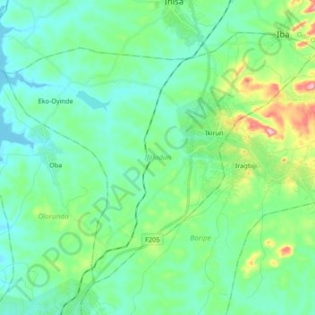
Name: Ifelodun topographic map, elevation, terrain.
Location: Ifelodun, Osun State, Nigeria (7.83878 4.55653 7.96894 4.72198)
Average elevation: 375 m
Minimum elevation: 326 m
Maximum elevation: 548 m
Thank you for supporting this site ❤️
Make a donation
Make a donation
Other topographic maps
Click on a map to view its topography, its elevation and its terrain.