
Make a donation
Manila topographic map
Click on the map to display elevation.
Make a donation
Manila
Almost all of Manila sits on top prehistoric alluvial deposits built by the waters of the Pasig River and on land reclaimed from Manila Bay. Manila's land has been substantially altered by human intervention; there has been considerable land reclamation along the waterfronts since the early-to-mid twentieth century. Some of the city's natural variations in topography have been leveled. As of 2013, Manila had a total area of 42.88 square kilometres (16.56 sq mi).
Make a donation
About this map
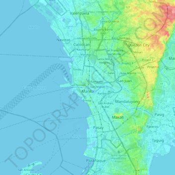
Name: Manila topographic map, elevation, terrain.
Location: Manila, Capital District, Metro Manila, Philippines (14.55082 120.79170 14.63955 121.02617)
Average elevation: 12 m
Minimum elevation: -3 m
Maximum elevation: 106 m
Make a donation
Other topographic maps
Click on a map to view its topography, its elevation and its terrain.
Make a donation
Make a donation
Mount Pandadagsaan
Philippines > Davao de Oro > New Bataan
Mount Tagubud, also known as Mount Pandadagsaan or White Peak, is the highest mountain in the province of Davao de Oro in the Philippines with an elevation of 2,650 metres (8,694 ft) above sea level. Located in New Bataan Davao de Oro, Davao Region in the island of Mindanao Philippines, Mount Tagubud is the…
Average elevation: 2,195 m
Make a donation
Make a donation
Basilan
Basilan National Park is at the eastern portion of the remaining public forest between the city of Isabela and the municipalities of Lamitan, Tipo-Tipo and Sumisip. The park has an elevation of 971 metres (3,186 ft) above sea level, and the tallest peak, Puno Mahaji or Basilan Peak, dominates the park's…
Average elevation: 42 m
Make a donation