
Thank you for supporting this site ❤️
Make a donation
Make a donation
Moonridge topographic map
Click on the map to display elevation.
Thank you for supporting this site ❤️
Make a donation
Make a donation
About this map
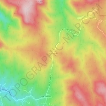
Name: Moonridge topographic map, elevation, terrain.
Location: Moonridge, Douglas County, Colorado, United States (39.34527 -105.13749 39.38527 -105.09749)
Average elevation: 2,273 m
Minimum elevation: 2,085 m
Maximum elevation: 2,427 m
Thank you for supporting this site ❤️
Make a donation
Make a donation
Other topographic maps
Click on a map to view its topography, its elevation and its terrain.
Thank you for supporting this site ❤️
Make a donation
Make a donation
Thank you for supporting this site ❤️
Make a donation
Make a donation