
Thank you for supporting this site ❤️
Make a donation
Make a donation
Upper Hardres topographic map
Click on the map to display elevation.
Thank you for supporting this site ❤️
Make a donation
Make a donation
About this map
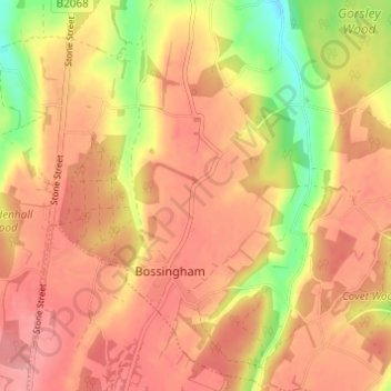
Name: Upper Hardres topographic map, elevation, terrain.
Location: Upper Hardres, Canterbury, Kent, England, United Kingdom (51.18865 1.05821 51.22692 1.10129)
Average elevation: 120 m
Minimum elevation: 56 m
Maximum elevation: 154 m
Thank you for supporting this site ❤️
Make a donation
Make a donation
Other topographic maps
Click on a map to view its topography, its elevation and its terrain.
Thank you for supporting this site ❤️
Make a donation
Make a donation
Thank you for supporting this site ❤️
Make a donation
Make a donation
Thank you for supporting this site ❤️
Make a donation
Make a donation
Thank you for supporting this site ❤️
Make a donation
Make a donation
Shalmsford Street
United Kingdom > England > Kent > Canterbury > Shalmsford Street
Average elevation: 54 m
Thank you for supporting this site ❤️
Make a donation
Make a donation
Reculver Country Park
United Kingdom > England > Kent > Canterbury > Hillborough
Average elevation: 10 m
Thank you for supporting this site ❤️
Make a donation
Make a donation
Thank you for supporting this site ❤️
Make a donation
Make a donation