
Thank you for supporting this site ❤️
Make a donation
Make a donation
Rhine topographic map
Click on the map to display elevation.
Thank you for supporting this site ❤️
Make a donation
Make a donation
About this map
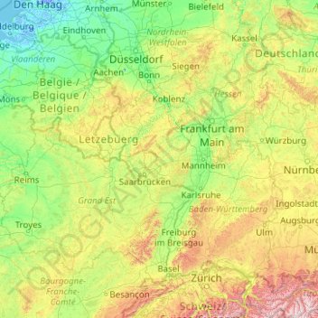
Name: Rhine topographic map, elevation, terrain.
Location: Rhine, 56340, Germany (46.82341 4.04960 52.00298 9.67088)
Average elevation: 363 m
Minimum elevation: -6 m
Maximum elevation: 3,448 m
Thank you for supporting this site ❤️
Make a donation
Make a donation
Other topographic maps
Click on a map to view its topography, its elevation and its terrain.