
Thank you for supporting this site ❤️
Make a donation
Make a donation
Carson topographic map
Click on the map to display elevation.
Thank you for supporting this site ❤️
Make a donation
Make a donation
About this map
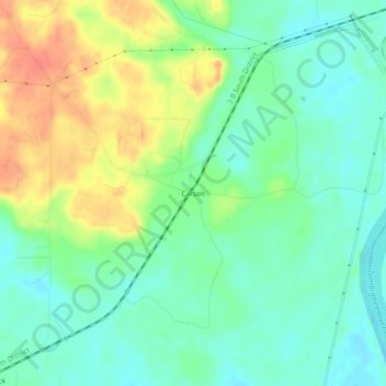
Name: Carson topographic map, elevation, terrain.
Location: Carson, Washington County, Alabama, 36548, United States (31.45239 -87.96139 31.49239 -87.92139)
Average elevation: 18 m
Minimum elevation: 0 m
Maximum elevation: 47 m
Thank you for supporting this site ❤️
Make a donation
Make a donation
Other topographic maps
Click on a map to view its topography, its elevation and its terrain.