
Make a donation
Barkin Ladi topographic map
Click on the map to display elevation.
Make a donation
About this map
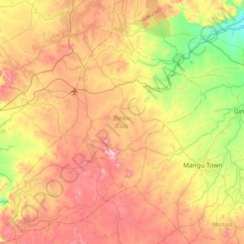
Name: Barkin Ladi topographic map, elevation, terrain.
Location: Barkin Ladi, Plateau State, Nigeria (9.32057 8.68942 9.83040 9.13878)
Average elevation: 1,209 m
Minimum elevation: 888 m
Maximum elevation: 1,610 m
Make a donation
Other topographic maps
Click on a map to view its topography, its elevation and its terrain.
Jos
Nigeria > Plateau State > Jos North
At an altitude of 1,217 m (3,993 ft) above sea level, Jos' climate is closer to temperate than that of the vast majority of Nigeria. Average monthly temperatures range from 21–25 °C (70–77 °F), and from mid-November to late January, night-time temperatures drop as low as 7 °C (45 °F). Hail sometimes…
Average elevation: 1,181 m
Make a donation
Make a donation