
Make a donation
Buxton topographic map
Click on the map to display elevation.
Make a donation
About this map
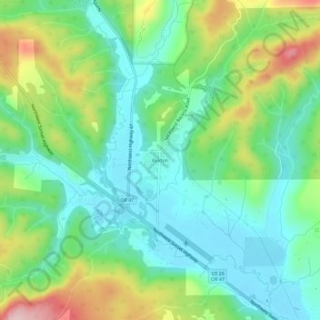
Name: Buxton topographic map, elevation, terrain.
Location: Buxton, Washington County, Oregon, 97125, United States (45.66877 -123.21093 45.70877 -123.17093)
Average elevation: 146 m
Minimum elevation: 69 m
Maximum elevation: 313 m
Make a donation
Other topographic maps
Click on a map to view its topography, its elevation and its terrain.
Beaverton
United States > Oregon > Washington County
As of January 2020, Beaverton covers a total area of 19.7 square miles (51 km2), all of it land except for small creeks, ponds, and lakes. The city is located along the eastern edge of the Tualatin Valley just west of the Tualatin Mountains. It is bordered by Portland to the east, Hillsboro to the west, and…
Average elevation: 106 m
Hillsboro
United States > Oregon > Washington County
Hillsboro is located at 45°31′N 122°59′W / 45.517°N 122.983°W / 45.517; -122.983 (Hillsboro, Oregon). The United States Census Bureau reports the city has a total area of 21.6 square miles (55.9 km2), all of which is land. In 2013, Hillsboro itself reported an area of 23.88 square miles…
Average elevation: 53 m
Make a donation
Tualatin River
United States > Oregon > Washington County
The drainage area of the river is approximately 712 square miles (1,840 km2) with 27 creeks feeding into the Tualatin. Its watershed is 15 percent urbanized, 35 percent agricultural, and 50 percent forested. The river drops 1,800 feet (550 m) in elevation during its first 12 miles (19 km) and then only an…
Average elevation: 117 m
Forest Glen Woods Natural Area
United States > Oregon > Washington County > Beaverton
Average elevation: 75 m
Make a donation
Make a donation
Beaverton
United States > Oregon > Washington County
As of January 2020, Beaverton covers a total area of 19.7 square miles (51 km2), all of it land except for small creeks, ponds, and lakes. The city is located along the eastern edge of the Tualatin Valley just west of the Tualatin Mountains. It is bordered by Portland to the east, Hillsboro to the west, and…
Average elevation: 106 m
Make a donation
Hillsboro
United States > Oregon > Washington County
The United States Census Bureau reports the city has a total area of 21.6 sq mi (55.9 km2), all of which is land. In 2013, Hillsboro itself reported an area of 23.88 sq mi (61.8 km2), equivalent to 15,283 acres (61.8 km2). The city is located in the Tualatin Valley, and the Tualatin River forms part of the…
Average elevation: 53 m
Make a donation
Hillsboro
United States > Oregon > Washington County
The United States Census Bureau reports the city has a total area of 21.6 sq mi (55.9 km2), all of which is land. In 2013, Hillsboro itself reported an area of 23.88 sq mi (61.8 km2), equivalent to 15,283 acres (61.8 km2). The city is located in the Tualatin Valley, and the Tualatin River forms part of the…
Average elevation: 53 m
Beaverton
United States > Oregon > Washington County
Beaverton covers a total area of 19.7 square miles (51 km2), all of it land except for small creeks, ponds, and lakes. The city is located along the eastern edge of the Tualatin Valley just west of the Tualatin Mountains. It is bordered by Portland to the east, Hillsboro to the west, and Tigard to the south.…
Average elevation: 106 m
Make a donation
Beaverton
United States > Oregon > Washington County
Beaverton covers a total area of 19.7 square miles (51 km2), all of it land except for small creeks, ponds, and lakes. The city is located along the eastern edge of the Tualatin Valley just west of the Tualatin Mountains. It is bordered by Portland to the east, Hillsboro to the west, and Tigard to the south.…
Average elevation: 106 m
Hillsboro
United States > Oregon > Washington County
The United States Census Bureau reports the city has a total area of 21.6 sq mi (55.9 km2), all of which is land. In 2013, Hillsboro itself reported an area of 23.88 sq mi (61.8 km2), equivalent to 15,283 acres (61.8 km2). The city is located in the Tualatin Valley, and the Tualatin River forms part of the…
Average elevation: 53 m
Vern Galaway Memorial Park
United States > Oregon > Washington County > North Plains
Average elevation: 56 m
Make a donation
Hillsboro
United States > Oregon > Washington County
Hillsboro is located at 45°31′N 122°59′W / 45.517°N 122.983°W / 45.517; -122.983 (Hillsboro, Oregon). The United States Census Bureau reports the city has a total area of 21.6 square miles (55.9 km2), all of which is land. In 2013, Hillsboro itself reported an area of 23.88 square miles…
Average elevation: 53 m