
Igman topographic map
Interactive map
Click on the map to display elevation.
About this map
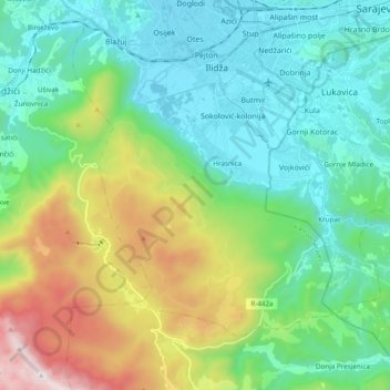
Name: Igman topographic map, elevation, terrain.
Location: Igman, Ilidza municipality, Sarajevo Canton, B&H (43.72396 18.20091 43.84744 18.40954)
Average elevation: 909 m
Minimum elevation: 483 m
Maximum elevation: 2,040 m
Other topographic maps
Click on a map to view its topography, its elevation and its terrain.
Zelenci
Zelenci, City of Banja Luka, Republika Srpska, B&H
Average elevation: 540 m
Central Bosnia Canton
B&H > Federation of Bosnia and Herzegovina
Central Bosnia Canton, Federation of Bosnia and Herzegovina, B&H
Average elevation: 940 m
Canton 10
B&H > Federation of Bosnia and Herzegovina
Canton 10, Federation of Bosnia and Herzegovina, B&H
Average elevation: 931 m
Galičica
B&H > Entity Federation of Bosnia and Herzegovina > Galičica
Galičica, Gornji Vakuf/Uskoplje municipality, Central Bosnia Canton, Entity Federation of Bosnia and Herzegovina, 70240, B&H
Average elevation: 796 m
Vučipolje
B&H > Federation of Bosnia and Herzegovina > Vučipolje
Vučipolje, Bugojno Municipality, Central Bosnia Canton, Federation of Bosnia and Herzegovina, 70230, B&H
Average elevation: 602 m
Glavatičevo
Glavatičevo, Konjic municipality, Herzegovina-Neretva Canton, B&H
Average elevation: 594 m
Čvrsnica
B&H > Entity Federation of Bosnia and Herzegovina > Turističko naselje Risovac
Čvrsnica, Put munike, Zelenike, Naselje Risovac, Turističko naselje Risovac, Jablanica municipality, Herzegovina-Neretva Canton, Entity Federation of Bosnia and Herzegovina, B&H
Average elevation: 1,359 m