
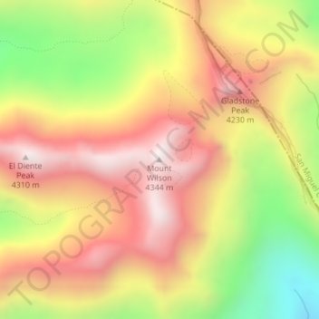
Mount Wilson topographic map
Interactive map
Click on the map to display elevation.
About this map
Name: Mount Wilson topographic map, elevation, terrain.
Average elevation: 3,891 m
Minimum elevation: 3,371 m
Maximum elevation: 4,291 m
Other topographic maps
Click on a map to view its topography, its elevation and its terrain.
Denver County
United States of America > Colorado
Denver County, Colorado, United States of America
Average elevation: 1,673 m
Eagle County
United States of America > Colorado
Eagle County, Colorado, United States of America
Average elevation: 2,769 m