
Eagle County topographic map
Interactive map
Click on the map to display elevation.
About this map
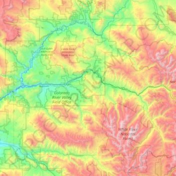
Name: Eagle County topographic map, elevation, terrain.
Location: Eagle County, Colorado, United States of America (39.34949 -107.11374 39.92530 -106.17557)
Average elevation: 2,769 m
Minimum elevation: 1,871 m
Maximum elevation: 4,196 m
The highest elevation in the county is the Mount of the Holy Cross which rises to 14,011 feet (4,271 m) above sea level. The lowest elevation is on the Colorado River at 6,128 feet (1,868 m).
Other topographic maps
Click on a map to view its topography, its elevation and its terrain.
Mount Wilson
United States of America > Colorado
Mount Wilson, Dolores County, Colorado, United States of America
Average elevation: 3,891 m
Denver County
United States of America > Colorado
Denver County, Colorado, United States of America
Average elevation: 1,673 m