
Owerri North topographic map
Interactive map
Click on the map to display elevation.
About this map
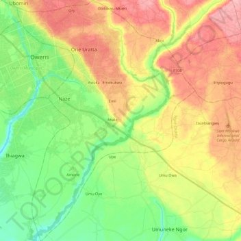
Name: Owerri North topographic map, elevation, terrain.
Location: Owerri North, Imo, Nigeria (5.32394 7.01391 5.54062 7.17482)
Average elevation: 87 m
Minimum elevation: 36 m
Maximum elevation: 147 m
Other topographic maps
Click on a map to view its topography, its elevation and its terrain.
Nguru
Nigeria > Imo > Aboh-Mbaise > Nguru
Nguru, Aboh-Mbaise, Imo, 462103, Nigeria
Average elevation: 128 m