
Brainerd topographic map
Interactive map
Click on the map to display elevation.
About this map
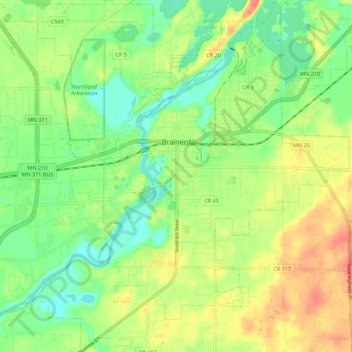
Name: Brainerd topographic map, elevation, terrain.
Location: Brainerd, Crow Wing County, Minnesota, 56401, United States (46.31263 -94.24592 46.38862 -94.14238)
Average elevation: 370 m
Minimum elevation: 348 m
Maximum elevation: 395 m
Other topographic maps
Click on a map to view its topography, its elevation and its terrain.
Bird Island
United States > Minnesota > Crow Wing County
Bird Island, Crow Wing County, Minnesota, United States
Average elevation: 386 m
Nokay Lake
United States > Minnesota > Crow Wing County
Nokay Lake, Crow Wing County, Minnesota, United States
Average elevation: 380 m
Emily Lake
United States > Minnesota > Crow Wing County > Emily
Emily Lake, Emily, Crow Wing County, Minnesota, United States
Average elevation: 386 m
Cross Lake
United States > Minnesota > Crow Wing County > Crosslake
Cross Lake, Crosslake, Crow Wing County, Minnesota, 56442, United States
Average elevation: 377 m
Breezy Point
United States > Minnesota > Crow Wing County
Breezy Point, Crow Wing County, Minnesota, United States
Average elevation: 377 m
Ossawinnamakee Lake
United States > Minnesota > Crow Wing County > Breezy Point
Ossawinnamakee Lake, Breezy Point, Crow Wing County, Minnesota, United States
Average elevation: 380 m
Boom Lake
United States > Minnesota > Crow Wing County > Brainerd
Boom Lake, Brainerd, Crow Wing County, Minnesota, United States
Average elevation: 367 m
Platte Lake
United States > Minnesota > Crow Wing County
Platte Lake, Crow Wing County, Minnesota, United States
Average elevation: 384 m
Pequot Lakes
United States > Minnesota > Crow Wing County
Pequot Lakes, Crow Wing County, Minnesota, 56472, United States
Average elevation: 383 m
Ironton
United States > Minnesota > Crow Wing County
Ironton, Crow Wing County, Minnesota, United States
Average elevation: 378 m
Brainerd
United States > Minnesota > Crow Wing County > Brainerd > Brainerd
Brainerd, Crow Wing County, Minnesota, 56401, United States
Average elevation: 369 m