
Sheffield topographic map
Click on the map to display elevation.
Sheffield
Sheffield nestles on the eastern foothills of the Pennines and is sculpted by a dramatic hill-and-valley system formed where five rivers — the Don, Sheaf, Rivelin, Loxley and Porter — converge, producing steep-sided valleys and gritstone ridgelines with much of the urban area built directly onto hillsides that give sweeping views across the city and out to the moors. The city’s elevation is strikingly varied: its low point is around 29 m above sea level at Blackburn Meadows while the highest ground reaches about 548 m at High Stones, a westward rise that carries the urban fringe into the high, windswept peat moorlands of the Peak District — roughly one-third of Sheffield’s area falls inside the national park. Most housing sits on mid-slopes (around 100–200 m) with the city centre nearer 70–80 m, producing a distinctive cityscape of river-cut gullies, steep residential terraces and open moorland shoulders that shaped Sheffield’s industrial past and now frames its views.
About this map
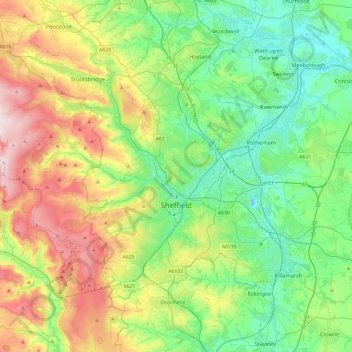
Name: Sheffield topographic map, elevation, terrain.
Location: Sheffield, South Yorkshire, England, United Kingdom (53.30451 -1.80147 53.50310 -1.32467)
Average elevation: 168 m
Minimum elevation: -5 m
Maximum elevation: 528 m
Other topographic maps
Click on a map to view its topography, its elevation and its terrain.
Coalville
United Kingdom > England > Leicestershire > North West Leicestershire
Average elevation: 149 m