
Thank you for supporting this site ❤️
Make a donation
Make a donation
Bald Head topographic map
Click on the map to display elevation.
Thank you for supporting this site ❤️
Make a donation
Make a donation
About this map
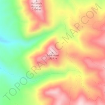
Name: Bald Head topographic map, elevation, terrain.
Location: Bald Head, Cache County, Utah, United States (41.47628 -111.76110 41.47638 -111.76100)
Average elevation: 1,944 m
Minimum elevation: 1,729 m
Maximum elevation: 2,124 m
Thank you for supporting this site ❤️
Make a donation
Make a donation
Other topographic maps
Click on a map to view its topography, its elevation and its terrain.
Clarkston
United States > Utah > Cache County
The townsite of Clarkston was laid out in 1864. It was named for Israel Justus Clark, who was an early settler and the first branch president of the Church of Jesus Christ of Latter-day Saints in Clarkston. The settlers originally settled east of modern-day Clarkston in a spot known as the flat. Due to water…
Average elevation: 1,498 m
Thank you for supporting this site ❤️
Make a donation
Make a donation
Thank you for supporting this site ❤️
Make a donation
Make a donation