
Make a donation
Genesee County topographic map
Click on the map to display elevation.
Make a donation
About this map
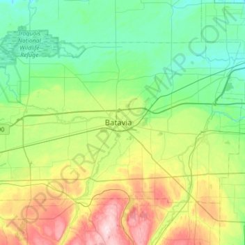
Name: Genesee County topographic map, elevation, terrain.
Location: Genesee County, New York, United States (42.86277 -78.46543 43.13304 -77.90418)
Average elevation: 269 m
Minimum elevation: 166 m
Maximum elevation: 554 m
Make a donation
Other topographic maps
Click on a map to view its topography, its elevation and its terrain.
Troy
United States > New York > Rensselaer County
The western edge of the city is flat along the river, and then steeply slopes to higher terrain to the east. The average elevation is 50 feet, with the highest elevation being 500 feet in the eastern part of the city. The city is longer than it is wide, with the southern part wider than the northern section of…
Average elevation: 137 m
East Hampton
United States > New York > Suffolk County > East Hampton > Village of East Hampton
Average elevation: 12 m
Make a donation
Port Jefferson
United States > New York > Suffolk County > Port Jefferson > Port Jefferson
It wasn't until 1836 that the local leadership truly initiated the community's transition from a swampish hamlet to a bustling port town. Twenty-two acres of the harborfront, which flooded with the tides, were brought to a stable elevation with the construction of a causeway. Concurrently, the village was…
Average elevation: 26 m
Michael Ciaiola Conservation Area
United States > New York > Putnam County > Town of Patterson > Putnam Lake
Average elevation: 294 m
Make a donation
Make a donation
Make a donation
Alfred
United States > New York > Allegany County > Alfred
The elevation of Alfred is about 1,700 feet (520 m) but rises to a high point of 2,355 feet (718 m) at the summit of Jericho Hill just south of the village. The hills greatly affect the weather in the region, which results in quick changes as well as different conditions in neighboring valleys.
Average elevation: 604 m
Make a donation
Mohonk Mountain House Property
United States > New York > Ulster County > Town of New Paltz
Average elevation: 228 m
Make a donation
Albany
United States > New York > Albany County > Albany
The highest natural point in Albany is a USGS benchmark near the Loudonville Reservoir off Birch Hill Road, at 378 feet (115 m) above sea level. The lowest point is sea level at the Hudson River (the average water elevation is 2 feet (0.61 m)), which is still technically an estuary at Albany and is affected by…
Average elevation: 114 m
Fort Ticonderoga
United States > New York > Essex County > Town of Ticonderoga
Average elevation: 58 m
Make a donation
Gloversville
United States > New York > Gloversville
The city sits in the foothills of the Adirondack Mountains and therefore is within a climatic transition zone. Gloversville experiences the warmer summer temperatures common throughout the Capital Region's Hudson and Mohawk Valleys while experiencing generally more copious precipitation throughout the year…
Average elevation: 275 m
Make a donation
Make a donation
Lake Mohansic
United States > New York > Westchester County > Town of Yorktown
Average elevation: 159 m
Make a donation
Lower Corners
United States > New York > Schenectady County > Town of Glenville
Average elevation: 205 m
Van Buren Point
United States > New York > Chautauqua County > Town of Portland
Average elevation: 177 m
Make a donation
Irving
United States > New York > Chautauqua County
Irving is a hamlet in Chautauqua County, New York, United States. (It also falls in Cattaraugus County and Erie County. The Cattaraugus County part of Irving is part of the Seneca Nation Native American territory, the Erie County part borders Brant, New York and also is part of the Seneca Nation territory. )…
Average elevation: 185 m
Findley Lake
United States > New York > Chautauqua County
Findley Lake is part of the town of Mina in southwestern Chautauqua County, New York, United States. Situated at an elevation of 1440 ft (439 m) above sea level, this hamlet is located on the north shore of Findley Lake.
Average elevation: 463 m
Make a donation
Murray Isle
United States > New York > Jefferson County > Town of Clayton > Grenell
Average elevation: 78 m
Dewittville
United States > New York > Chautauqua County > Town of Chautauqua
Average elevation: 425 m
Make a donation
Woods Mills
United States > New York > Clinton County > Town of Schuyler Falls
Average elevation: 211 m
Make a donation
Make a donation
Make a donation
Owasco Lake Station
United States > New York > Cayuga County > Town of Fleming
Average elevation: 252 m
Make a donation
Make a donation
Make a donation
Make a donation
Make a donation
Make a donation
Make a donation
Make a donation
Make a donation