
Make a donation
Adams Basin topographic map
Click on the map to display elevation.
Make a donation
About this map
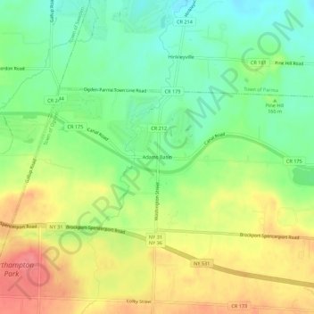
Name: Adams Basin topographic map, elevation, terrain.
Location: Adams Basin, Town of Ogden, New York, 14410, United States (43.17756 -77.87390 43.21756 -77.83390)
Average elevation: 163 m
Minimum elevation: 130 m
Maximum elevation: 201 m
Make a donation
Other topographic maps
Click on a map to view its topography, its elevation and its terrain.
City of Oswego
United States > New York > Oswego County
Oswego is located on the southeastern shore of Lake Ontario at the mouth of the Oswego River, approximately 35 miles north of Syracuse and 69 miles east of Rochester. The elevation is 298 feet above sea level. The nearest city is Fulton, located south of Oswego and north of Syracuse.
Average elevation: 87 m
Make a donation
Catskill Park
New York's wilderness areas must be composed of 10,000 acres (4,000 ha; 40 km2) of contiguous land, twice the federal standard. Land is to be left as "untrammeled by man" and as close to its natural state as possible, offering outstanding opportunities for solitude. No artificially-powered devices are…
Average elevation: 501 m
Make a donation
Town of East Greenbush
United States > New York > Rensselaer County
The western section of the town, along the Hudson River is marked by bluffs that rise to an elevation of between 100 and 300 feet. The little flat land that exists along the river is on the Papscanee Island. Papscanee Island is actually a peninsula, separated from the rest of the town by the Papscanee Creek.…
Average elevation: 89 m
Mohonk Mountain House Property
United States > New York > Ulster County > Town of New Paltz
Average elevation: 228 m
Make a donation
Michael Ciaiola Conservation Area
United States > New York > Putnam County > Town of Patterson > Putnam Lake
Average elevation: 294 m
Make a donation
Cayuga Lake
United States > New York > Cayuga County > Village of Union Springs
Average elevation: 264 m
Make a donation
Make a donation
Genesee River
Only a small creek (Irondequoit Creek) flows in what is left of this large paleogeologic valley. The area of the lower river was also affected. Since the earth rebounded from the melting glaciers more rapidly in Canada than in New York, water from Lake Ontario was spilled over New York due to its lower…
Average elevation: 397 m
Make a donation
Great Sacandaga Lake
United States > New York > Fulton County > Town of Hadley
Average elevation: 370 m
Averill Park
United States > New York > Rensselaer County > Town of Sand Lake
Average elevation: 246 m
Make a donation
Manhattan Island
United States > New York > New York
Marble Hill is one example of how Manhattan's land has been considerably altered by human intervention. The borough has seen substantial land reclamation along its waterfronts since Dutch colonial times, and much of the natural variation in its topography has been evened out.
Average elevation: 17 m
Make a donation
Saratoga Spa State Park
United States > New York > Saratoga County > City of Saratoga Springs
Average elevation: 91 m
Make a donation
Village of New Paltz
United States > New York > Ulster County > Town of New Paltz
Average elevation: 84 m
Make a donation
Make a donation
Village of Valley Stream
United States > New York > Nassau County
At this time, the community did not have a post office, so residents had to pick up their mail in the village of Hempstead. After Pagan petitioned authorities for a post office, he was appointed postmaster and it was based in his farmhouse, now known as the Pagan-Fletcher House. He was advised that the…
Average elevation: 7 m
Make a donation
Village of Elmira Heights
United States > New York > Chemung County > Town of Horseheads
Average elevation: 278 m
Lake Mohansic
United States > New York > Westchester County > Town of Yorktown
Average elevation: 159 m
Make a donation
Make a donation
Village of Cassadaga
United States > New York > Chautauqua County > Town of Stockton
Cassadaga is located on the northwestern edge of the Allegheny Plateau in western New York at 42°20'29" north, 79°18'56" west (42.341343, -79.315653) at an elevation of approximately 1,340 feet (410 m) above sea level. The village is located at the south end of Lower Cassadaga Lake, Lily Dale being located…
Average elevation: 418 m
Make a donation
Make a donation
Charles E. Baker State Forest
United States > New York > Madison County > Town of Brookfield
Average elevation: 482 m
Murray Isle
United States > New York > Jefferson County > Town of Clayton > Grenell
Average elevation: 78 m
Make a donation
Make a donation
Make a donation
Make a donation
Make a donation
Shindagin Hollow State Forest
United States > New York > Tompkins County > Town of Caroline
Average elevation: 457 m
Lake Roxanne
United States > New York > Clinton County > Town of Ellenburg > Ellenburg Depot
Average elevation: 280 m
Make a donation
Make a donation
Upper Saint Regis Lake
United States > New York > Franklin County > Town of Harrietstown
Average elevation: 506 m
Make a donation