
Gelderland topographic map
Interactive map
Click on the map to display elevation.
About this map
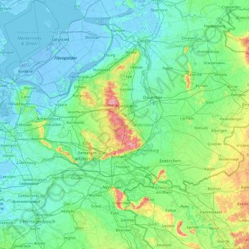
Name: Gelderland topographic map, elevation, terrain.
Location: Gelderland, Nederland (51.73358 4.99385 52.52203 6.83280)
Average elevation: 14 m
Minimum elevation: -8 m
Maximum elevation: 108 m
Other topographic maps
Click on a map to view its topography, its elevation and its terrain.
Voorthuizen
Voorthuizen, Barneveld, Gelderland, Nederland
Average elevation: 15 m
Harderwijk
Nederland > Gelderland > Harderwijk
Harderwijk, Gelderland, Nederland
Average elevation: 7 m
Alphen aan den Rijn
Alphen aan den Rijn, Zuid-Holland, Nederland
Average elevation: -2 m
Voorburg
Voorburg, Leidschendam-Voorburg, Zuid-Holland, Nederland
Average elevation: 3 m
Gorinchem
Nederland > Zuid-Holland > Gorinchem
Gorinchem, Zuid-Holland, Nederland
Average elevation: 1 m
Den Helder
Nederland > Noord-Holland > Den Helder
Den Helder, Noord-Holland, Nederland
Average elevation: 0 m
Utrechtse Heuvelrug
Utrechtse Heuvelrug, Utrecht, Nederland
Average elevation: 10 m