Geolocate

Singhbhūm topographic map

Interactive map

Click on the map to display elevation.

About this map

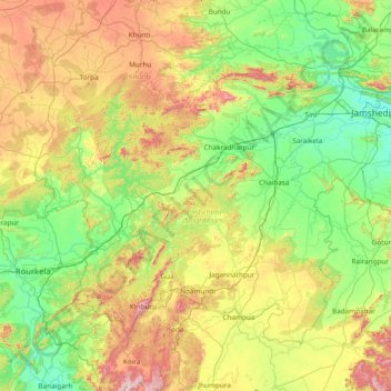
Name: Singhbhūm topographic map, elevation, terrain.

Location: Singhbhūm, Pashchimi Singhbhum, Jharkhand, India (21.80000 84.80000 23.20000 86.20000)

Average elevation: 379 m

Minimum elevation: 120 m

Maximum elevation: 1,089 m

Other topographic maps

Click on a map to view its topography, its elevation and its terrain.

Kodarma

India > Jharkhand

Kodarma, Jharkhand, India

Average elevation: 271 m

Isri

India > Jharkhand > Isri

Isri, Girīdīh, Giridih, Jharkhand, India

Average elevation: 282 m

Gamharia

India > Jharkhand > Gamharia

Gamharia, Seraikela Kharsawan, Jharkhand, 832108, India

Average elevation: 144 m

Seraikela Kharsawan

India > Jharkhand

Seraikela Kharsawan, Jharkhand, India

Average elevation: 252 m