Geolocate

Kodarma topographic map

Interactive map

Click on the map to display elevation.

About this map

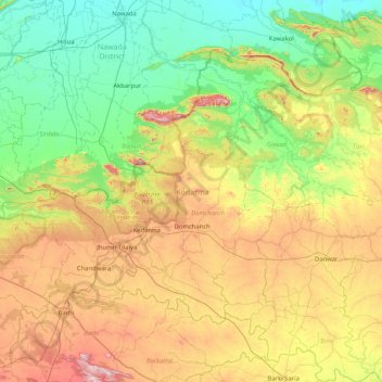
Name: Kodarma topographic map, elevation, terrain.

Location: Kodarma, Jharkhand, India (24.26262 85.07938 24.82255 85.90450)

Average elevation: 271 m

Minimum elevation: 70 m

Maximum elevation: 674 m

Other topographic maps

Click on a map to view its topography, its elevation and its terrain.

Isri

India > Jharkhand > Isri

Isri, Girīdīh, Giridih, Jharkhand, India

Average elevation: 282 m

Gamharia

India > Jharkhand > Gamharia

Gamharia, Seraikela Kharsawan, Jharkhand, 832108, India

Average elevation: 144 m

Singhbhūm

India > Jharkhand

Singhbhūm, Pashchimi Singhbhum, Jharkhand, India

Average elevation: 379 m

Seraikela Kharsawan

India > Jharkhand

Seraikela Kharsawan, Jharkhand, India

Average elevation: 252 m