
Make a donation
Palomares topographic map
Click on the map to display elevation.
Make a donation
About this map
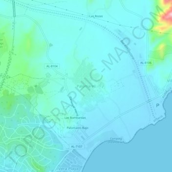
Name: Palomares topographic map, elevation, terrain.
Average elevation: 23 m
Minimum elevation: -3 m
Maximum elevation: 208 m
Make a donation
Other topographic maps
Click on a map to view its topography, its elevation and its terrain.
Granada
Spain > Andalusia > Comarca de la Vega de Granada
Granada (Spanish: [ɡɾaˈnaða], locally [ɡɾaˈna]) is the capital city of the province of Granada, in the autonomous community of Andalusia, Spain. Granada is located at the foot of the Sierra Nevada mountains, at the confluence of four rivers, the Darro, the Genil, the Monachil and the Beiro. Ascribed to…
Average elevation: 829 m
Marbella
Spain > Andalusia > Costa del Sol Occidental
There are five geomorphological units: the Sierra Blanca, the Sierra Blanca piedmont (foothills), the lower hill country, the plains and the coastal dunes. The Sierra Blanca is most centrally located in the province, looming over the old village. This mountain range has three peaks: La Concha, located further…
Average elevation: 216 m
Seville
Seville has an area of 141 km2 (54 sq mi), according to the National Topographic Map (Mapa Topográfico Nacional) series from the Instituto Geográfico Nacional – Centro Nacional de Información Geográfica, the country's civilian survey organisation (pages 984, 985 and 1002). The city is situated in the…
Average elevation: 35 m
Málaga
Spain > Andalusia > Málaga-Costa del Sol
Like many of the military fortifications that were constructed in Islamic Spain, the Alcazaba of Málaga featured a quadrangular plan. It was protected by an outer and inner wall, both supported by rectangular towers, between which a covered walkway led up the slope to the Gibralfaro (this was the only…
Average elevation: 276 m
Make a donation
Estepona
Spain > Andalusia > Costa del Sol Occidental
Estepona (Spanish pronunciation: [esteˈpona]) is a town and municipality in the comarca of the Costa del Sol, southern Spain. It is located in the province of Málaga, part of the autonomous community of Andalusia. Its district covers an area of 137 square kilometers in a fertile valley crossed by small…
Average elevation: 265 m
Make a donation
Cádiz
Spain > Andalusia > Bay of Cádiz
The Baluarte de la Candelaria (fortress or stronghold of Candlemas) is a military fortification. Taking advantage of a natural elevation of land, it was constructed in 1672 at the initiative of the governor, Diego Caballero de Illescas. Protected by a seaward-facing wall that had previously served as a…
Average elevation: 1 m
Make a donation
Granada
Spain > Andalusia > Comarca de la Vega de Granada
Granada (Spanish: [ɡɾaˈnaða], locally [ɡɾaˈna]) is the capital city of the province of Granada, in the autonomous community of Andalusia, Spain. Granada is located at the foot of the Sierra Nevada mountains, at the confluence of four rivers, the Darro, the Genil, the Monachil and the Beiro. Ascribed to…
Average elevation: 829 m
Cádiz
The entire province of Cádiz has a Mediterranean climate, mostly Köppen Csa but also Csb in high altitude areas. Large differences in summer temperatures exist between the three official stations in Cádiz, Jerez, and Tarifa depending on position relative to the coastline. Tarifa is exceptionally mild for…
Average elevation: 127 m
Make a donation
Almeria
During the winter, daily maximum temperatures tend to stay around 17–18 °C (63–64 °F). At night, the minimum temperature is usually around 8–10 °C (47–50 °F). This makes Almería the city with the second warmest winters in Spain and Europe, just after Cádiz. The city only receives 26 days of…
Average elevation: 97 m
Alhambra
Spain > Andalusia > Partido Judicial de Granada > Granada
During the reign of the Nasrid Dynasty, the Alhambra was transformed into a palatine city, complete with an irrigation system composed of aqueducts and water channels that provided water for the complex and for other nearby countryside palaces such as the Generalife. Previously, the old fortresses on the hill…
Average elevation: 759 m
Mijas
Spain > Andalusia > Costa del Sol Occidental
The climate changes gradually with increasing elevation in the mountains. Temperatures can drop to 10 °C (50 °F). In the peaks, over 600 m (2,000 ft) high, some ice may form in winter, while precipitation increases to almost 800 mm (32 in).
Average elevation: 171 m
Make a donation
Make a donation
Lucena
Lucena is located in the transition zone between the campiña in the Guadalquivir Depression and the Subbaetic system, at an altitude above mean sea level slightly below 500 meters. The Subbaetic system include neighboring subranges such as the sierras of Cabra, Carcabuey, Pollos, Horconera, and Rute.
Average elevation: 476 m
Málaga
Spain > Andalusia > Málaga-Costa del Sol
Like many of the military fortifications that were constructed in Islamic Spain, the Alcazaba of Málaga featured a quadrangular plan. It was protected by an outer and inner wall, both supported by rectangular towers, between which a covered walkway led up the slope to the Gibralfaro (this was the only…
Average elevation: 276 m
Make a donation
Güéjar Sierra
Spain > Andalusia > Comarca de la Vega de Granada
Güéjar Sierra is a village and municipality located in the province of Granada, Spain. According to the INE, it had a population of 2,988 at the start of 2010. The village is situated in the north-western part of the Sierra Nevada mountain range, at an altitude of 1,088 metres. The municipality borders Pinos…
Average elevation: 1,571 m
Make a donation
Granada
Spain > Andalusia > Partido Judicial de Granada
Granada (/ɡrəˈnɑːdə/ grə-NAH-də; Spanish: [ɡɾaˈnaða] ) is the capital city of the province of Granada, in the autonomous community of Andalusia, Spain. Granada is located at the foot of the Sierra Nevada mountains, at the confluence of four rivers, the Darro, the Genil, the Monachil and the Beiro.…
Average elevation: 829 m
Make a donation
Guadix
Spain > Andalusia > Comarca de Guadix
The city lies at an altitude of 913 metres, in the centre of the Hoya of Guadix, a high plain at the northern foothills of the Sierra Nevada. It is located on the Linares Baeza–Almería railway. The city was built in the vicinity of gullies and badlands.
Average elevation: 1,043 m
Alhaurín el Grande
Spain > Andalusia > Valle del Guadalhorce > Alhaurín el Grande
Average elevation: 291 m
Make a donation
Baeza
The town stands at a high elevation about 3 miles (4.8 km) from the right bank of the Guadalquivir in the Loma de Úbeda. Under the Romans, the town was known as 'Beatia'. Following its conquest by the Visigoths, Beatia was the seat of a bishopric of Baeza (viz.). From the beginning of the seventh century it…
Average elevation: 485 m
Make a donation
Chiclana de la Frontera
Spain > Andalusia > Bay of Cádiz
Chiclana de la Frontera (Spanish pronunciation: [tʃiˈklana ðe la fɾonˈteɾa]) is a town and municipality in southwestern Spain, in the province of Cádiz, Andalucía, near the Gulf of Cádiz. It belongs to the association of municipalities of the Bay of Cádiz (Bahía de Cádiz), the provincial capital of…
Average elevation: 24 m
Make a donation
Parque Natural Sierra de Tejeda, Almijara y Alhama
Spain > Andalusia > Comarca de Alhama
Average elevation: 754 m
Córdoba
The differences in elevation in the Valley are very small, ranging from 100 and 170 metres above sea level, with the city proper located at an average altitude of roughly 125 metres above sea level. The landscape of the valley is further subdivided in the piedmont connecting with the Sierra, the fluvial…
Average elevation: 281 m
Make a donation
Arriate
Spain > Andalusia > Serranía de Ronda
In spite of the scarcity of facts known about the history of Arriate, judging by the caves in the rocks on the banks of the river, it is possible that man's presence in these lands comes from very remote times. Its geographical situation in an area of soft topography and water, as well as the possibilities of…
Average elevation: 658 m
Make a donation
Make a donation
Jardines del Triunfo
Spain > Andalusia > Comarca de la Vega de Granada > Granada
Average elevation: 719 m
Make a donation
Make a donation
Jimena de la Frontera
Spain > Andalusia > Campo de Gibraltar
Jimena de la Frontera enjoys a moderate Mediterranean climate. There are 3,000 hours of sunshine per year, which contributes to average temperatures of between 18 and 20 °C (64 and 68 °F). However, the rainfall pattern differs significantly from the rest of southern Spain, due to the topography of the Strait…
Average elevation: 269 m
Almadén de la Plata
Almadén de la Plata is a municipality in Seville, Spain. It had a population of 1,696 in 2005 and has population density of 6.6 people per km2, with a total area of about 256 km2. It is located at an altitude of 450 meters and is 59 kilometers from Seville.
Average elevation: 418 m
Make a donation
Sierra de la Huerta del Abad
Spain > Andalusia > Sierra de Huelva > Aracena > Carboneras
Average elevation: 525 m
Cómpeta
Spain > Andalusia > La Axarquía
The highest point visible from the town is the Maroma (2,065 m). The topography of the terminus is quite hilly, especially in the northwest, which borders the province of Granada. Other important elevations are Cerro Lucero (1,779 m), Cisne (1,600 m), Verde (1,554 m) and Tajo de las Grajas, which has a length…
Average elevation: 694 m
Make a donation
Make a donation
Córdoba
The differences in elevation in the Valley are very small, ranging from 100 and 170 metres above sea level, with the city proper located at an average altitude of roughly 125 metres above sea level. The landscape of the valley is further subdivided in the piedmont connecting with the Sierra, the fluvial…
Average elevation: 281 m
Make a donation
Canillas de Aceituno
Spain > Andalusia > La Axarquía
Canillas de Aceituno has an altitude of around 524 meters at the foot of the Sierra de Tejeda and is crowned by the peak of La Maroma at 2,068 meters, the highest in the province. It is a town of narrow streets that are immaculately whitewashed, Moorish arches and corners of flowers.
Average elevation: 677 m
Make a donation
Make a donation
Jaén
Jaén has a hot-summer Mediterranean climate (Köppen climate classification: Csa), closely bordering on a cold semi-arid climate (BSk) with dry, hot summers and mild, moderately wet winters. Jaén has a July high of 33.9 °C (93.0 °F), and mean low of 21.3 °C (70.3 °F) with a mean temperature of 27.6 °C…
Average elevation: 606 m
Make a donation
Seville
Seville has an area of 141 km2 (54 sq mi), according to the National Topographic Map (Mapa Topográfico Nacional) series from the Instituto Geográfico Nacional – Centro Nacional de Información Geográfica, the country's civilian survey organisation (pages 984, 985 and 1002). The city is situated in the…
Average elevation: 35 m
Capileira
Spain > Andalusia > Comarca de la Alpujarra Granadina
Capileira is the highest and most northerly of the three villages in the gorge of the Poqueira river in the La Alpujarra district of the province of Granada, in Spain. It is located at latitude 36° 57' N and longitude 3° 21' W, about 1 km north of Bubión. Its altitude is officially recorded as 1436 metres,…
Average elevation: 2,384 m
Trevélez
Spain > Andalusia > Comarca de la Alpujarra Granadina
The river Trevélez flows through the village, which lies at the confluence of the river with a smaller stream. It is divided into three parts, the Barrios Bajo, Medio and Alto (lower, mid and upper quarters), with 200 metres of altitude difference between the highest and lowest points. The only bridge over…
Average elevation: 2,351 m
Make a donation