Thank you for supporting this site ❤️
Make a donation
Make a donation
Nottingham topographic map
Click on the map to display elevation.
Thank you for supporting this site ❤️
Make a donation
Make a donation
About this map
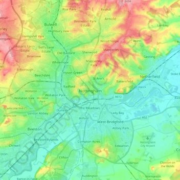
Name: Nottingham topographic map, elevation, terrain.
Location: Nottingham, East Midlands, England, United Kingdom (52.88901 -1.24696 53.01867 -1.08612)
Average elevation: 56 m
Minimum elevation: 16 m
Maximum elevation: 140 m
Thank you for supporting this site ❤️
Make a donation
Make a donation
Other topographic maps
Click on a map to view its topography, its elevation and its terrain.
Coalville
United Kingdom > England > Leicestershire > North West Leicestershire
Average elevation: 149 m
Thank you for supporting this site ❤️
Make a donation
Make a donation
Thank you for supporting this site ❤️
Make a donation
Make a donation
Thank you for supporting this site ❤️
Make a donation
Make a donation
Thank you for supporting this site ❤️
Make a donation
Make a donation
Thank you for supporting this site ❤️
Make a donation
Make a donation
Thank you for supporting this site ❤️
Make a donation
Make a donation
