Geolocate
Thank you for supporting this site ❤️Make a donation

Norfolk topographic map

Click on the map to display elevation.

About this map

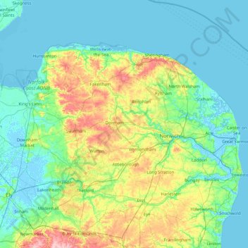
Name: Norfolk topographic map, elevation, terrain.

Location: Norfolk, England, United Kingdom (52.35534 0.15362 52.99164 1.74578)

Average elevation: 23 m

Minimum elevation: -4 m

Maximum elevation: 126 m

Other topographic maps

Click on a map to view its topography, its elevation and its terrain.

River Mersey

United Kingdom > England > Trafford > Warburton

River Mersey, Warburton, Trafford, Greater Manchester, England, WA3 6HY, United Kingdom

Average elevation: 17 m

Leighton Buzzard

United Kingdom > England > Central Bedfordshire

Leighton Buzzard, Central Bedfordshire, England, LU7 1EE, United Kingdom

Average elevation: 103 m

Rushcliffe

United Kingdom > England > Nottinghamshire

Rushcliffe, Nottinghamshire, England, United Kingdom

Average elevation: 63 m

Sutton Courtenay

United Kingdom > England > Oxfordshire > Vale of White Horse

Sutton Courtenay, Vale of White Horse, Oxfordshire, England, United Kingdom

Average elevation: 56 m

Chapeltown

United Kingdom > England > Sheffield

Chapeltown, Sheffield, South Yorkshire Mayoral Combined Authority, England, S35 2UU, United Kingdom

Average elevation: 113 m

Carisbrooke

United Kingdom > England > Isle of Wight

Carisbrooke, Isle of Wight, South East England, England, PO30 1NS, United Kingdom

Average elevation: 42 m

Canterbury

United Kingdom > England > Kent

Canterbury, Kent, South East England, England, CT1 2JQ, United Kingdom

Average elevation: 50 m

England

United Kingdom

England, United Kingdom

Average elevation: 55 m

Stanford on Soar

United Kingdom > England > Rushcliffe

Stanford on Soar, Rushcliffe, Nottinghamshire, East Midlands, England, United Kingdom

Average elevation: 61 m

London

United Kingdom > England > Greater London

London, Westminster, Greater London, England, United Kingdom

Average elevation: 66 m

Mylor Bridge

United Kingdom > England

Mylor Bridge, Cornwall, South West England, England, TR11 5NA, United Kingdom

Average elevation: 35 m

Swindon

United Kingdom > England

Swindon, South West England, England, SN1 1JZ, United Kingdom

Average elevation: 108 m

Walsall

United Kingdom > England

Walsall, West Midlands Combined Authority, West Midlands, England, United Kingdom

Average elevation: 145 m

Surrey

United Kingdom > England

Surrey, South East, England, United Kingdom

Average elevation: 69 m

Tring

United Kingdom > England

Tring, Hertfordshire, East of England, England, HP23 5AB, United Kingdom

Average elevation: 157 m

City of Westminster

United Kingdom > England

City of Westminster, London, Greater London, England, United Kingdom

Average elevation: 23 m

In order to remain free and to keep improving, this site uses cookies created by Google to compile visit statistics and display personalized advertisements.

How is the collected data used?