
Thank you for supporting this site ❤️
Make a donation
Make a donation
Elm Springs topographic map
Click on the map to display elevation.
Thank you for supporting this site ❤️
Make a donation
Make a donation
About this map
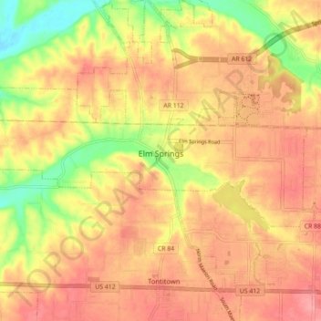
Name: Elm Springs topographic map, elevation, terrain.
Average elevation: 380 m
Minimum elevation: 327 m
Maximum elevation: 411 m
Thank you for supporting this site ❤️
Make a donation
Make a donation
Other topographic maps
Click on a map to view its topography, its elevation and its terrain.
Thank you for supporting this site ❤️
Make a donation
Make a donation
Thank you for supporting this site ❤️
Make a donation
Make a donation
Washington Mountain
United States > Arkansas > Washington County > Fayetteville
Average elevation: 409 m
Fayetteville
United States > Arkansas > Washington County > Fayetteville
...yet I venture the assertion that nowhere in said country—or for that matter, in any part of the state—could be found a lovelier elevation, or a lovelier grove of graceful oaks, or a more commanding view, or, in fine, a spot better suited and adapted for the purposes designated than the one chosen for…
Average elevation: 404 m
Thank you for supporting this site ❤️
Make a donation
Make a donation