
Gwalior topographic map
Interactive map
Click on the map to display elevation.
About this map
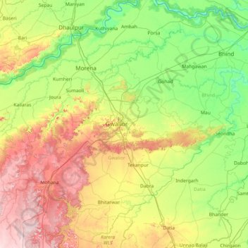
Name: Gwalior topographic map, elevation, terrain.
Location: Gwalior, Madhya Pradesh, 474002, India (25.56000 77.56000 26.84000 78.84000)
Average elevation: 217 m
Minimum elevation: 106 m
Maximum elevation: 472 m
Other topographic maps
Click on a map to view its topography, its elevation and its terrain.
Ashoknagar
Ashoknagar is situated at the average elevation of 507 metres(1640 ft) above sea level. It is in the plateau region. It has an agricultural topography. The plateau is an extension of the Deccan Traps, formed between 60 and 68 million years ago at the end of the Cretaceous period. In this region, the main…
Average elevation: 447 m