Geolocate

Kottayam topographic map

Interactive map

Click on the map to display elevation.

About this map

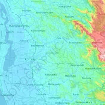
Name: Kottayam topographic map, elevation, terrain.

Location: Kottayam, Kerala, India (9.40026 76.36565 9.85729 76.98451)

Average elevation: 124 m

Minimum elevation: -6 m

Maximum elevation: 1,397 m

Other topographic maps

Click on a map to view its topography, its elevation and its terrain.

Kumily

India > Kerala > Peerumade

Average elevation: 936 m

Munnar

India > Kerala > Devikulam

Average elevation: 1,603 m

Mala

India > Kerala > Chalakkudy

Average elevation: 8 m

Chenappady

India > Kerala > Kanjirappally > Chenappady

Average elevation: 64 m

Porur

India > Kerala > Porur

Average elevation: 741 m

Kottayam

India > Kerala > Kottayam

Average elevation: 9 m

Ernakulam

India > Kerala > Ernakulam

The City of Ernakulam is situated in the Ernakulam District of Central Kerala in India. Ernakulam is located at 9°59′N 76°17′E / 9.98°N 76.28°E / 9.98; 76.28. It has an average elevation of 4 m (13 ft).

Average elevation: 8 m