
Make a donation
Borough of Luton topographic map
Click on the map to display elevation.
Make a donation
Borough of Luton
The local climate around Luton is differentiated somewhat from much of South East England due to its position in the Chiltern Hills, meaning it tends to be 1–2 degrees Celsius cooler than the surrounding towns – often flights at Luton airport, lying 160 m (525 ft) above sea level, will be suspended when marginal snow events occur, while airports at lower elevations, such as Heathrow, at 25 m (82 ft) above sea level, continue to function. Absolute temperature extremes recorded at Rothamsted Research Station, 5 miles (8 km) south south east of Luton town centre and at a similar elevation range from −17.0 °C (1.4 °F) in December 1981 and −16.7 °C (1.9 °F) in January 1963 to 36.6 °C (97.9 °F) in July 2019 and 33.8 °C (92.8 °F) in August 1990 and July 2006. Records for Rothamsted date back to 1901.
Make a donation
About this map
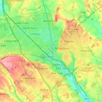
Name: Borough of Luton topographic map, elevation, terrain.
Location: Borough of Luton, England, United Kingdom (51.85447 -0.50595 51.92774 -0.34992)
Average elevation: 146 m
Minimum elevation: 94 m
Maximum elevation: 215 m
Make a donation
Other topographic maps
Click on a map to view its topography, its elevation and its terrain.
Make a donation
Coalville
United Kingdom > England > Leicestershire > North West Leicestershire
Average elevation: 149 m
Make a donation
Make a donation
Make a donation
Make a donation
Make a donation