
Make a donation
Telangana topographic map
Click on the map to display elevation.
Make a donation
About this map
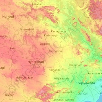
Name: Telangana topographic map, elevation, terrain.
Location: Telangana, India (15.83642 77.23659 19.91730 81.32262)
Average elevation: 320 m
Minimum elevation: 0 m
Maximum elevation: 1,262 m
Make a donation
Other topographic maps
Click on a map to view its topography, its elevation and its terrain.
Darbhanga
Darbhanga is located in the northern part of Bihar. It lies between 25.53 degrees - 26.27 degrees N and 85.45 degrees - 86.25 degrees E at an average elevation of 171 feet (52 m). Darbhanga district covers an area of 2,279 sq km. Darbhanga is bounded by Madhubani district in the north, Samastipur district in…
Average elevation: 50 m
Make a donation
Chennai
Chennai is located on the south–eastern coast of India in the north–eastern part of Tamil Nadu on a flat coastal plain known as the Eastern Coastal Plains with an average elevation of 6.7 m (22 ft) and highest point at 60 m (200 ft). Chennai's soil is mostly clay, shale and sandstone. Clay underlies most…
Average elevation: 7 m
Make a donation
Make a donation
Make a donation
Kalaburagi
India > Karnataka > Kalaburagi taluku > Kalaburagi
The entire district is on the Deccan Plateau, and the elevation ranges from 300 to 750 m above MSL. Two main rivers, the Krishna and Bhima, flow through the district. The predominant soil type is black soil. The district has many tanks, which irrigate the land along with the river. The Upper Krishna Project is…
Average elevation: 465 m
Make a donation