
Thank you for supporting this site ❤️
Make a donation
Make a donation
Baruten topographic map
Click on the map to display elevation.
Thank you for supporting this site ❤️
Make a donation
Make a donation
About this map
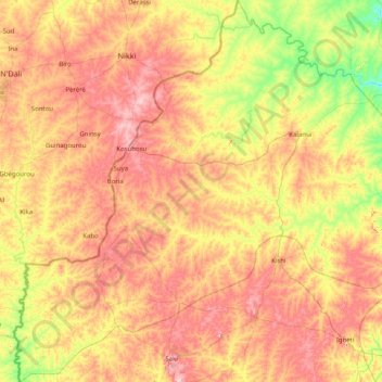
Name: Baruten topographic map, elevation, terrain.
Location: Baruten, Kwara State, Nigeria (8.57565 2.72931 10.16833 3.82332)
Average elevation: 354 m
Minimum elevation: 203 m
Maximum elevation: 562 m
Thank you for supporting this site ❤️
Make a donation
Make a donation
Other topographic maps
Click on a map to view its topography, its elevation and its terrain.
Omu Aran
Nigeria > Kwara State > Irepodun
Omu Aran has a tropical wet and dry or savanna climate and is located at an elevation of 536.14 meters (1758.99 feet) above sea level (Classification: Aw). The district's average annual temperature is 0.26% higher than Nigeria's averages at 29.72°C (85.5°F). Omu Aran generally has 149.31 wet days per year…
Average elevation: 539 m
Thank you for supporting this site ❤️
Make a donation
Make a donation