
Make a donation
West Bengal topographic map
Click on the map to display elevation.
Make a donation
West Bengal
The distribution of vegetation in northern West Bengal is dictated by elevation and precipitation. For example, the foothills of the Himalayas, the Dooars, are densely wooded with sal and other tropical evergreen trees. Above an elevation of 1,000 metres (3,300 ft), the forest becomes predominantly subtropical. In Darjeeling, which is above 1,500 metres (4,900 ft), temperate forest trees like oaks, conifers and rhododendrons predominate.
Make a donation
About this map
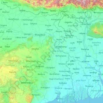
Name: West Bengal topographic map, elevation, terrain.
Location: West Bengal, India (21.54730 85.81967 27.22107 89.88260)
Average elevation: 182 m
Minimum elevation: -2 m
Maximum elevation: 4,101 m
Make a donation
Other topographic maps
Click on a map to view its topography, its elevation and its terrain.
Maharashtra
Maharashtra is the third largest state by area in India. The Western Ghats better known as Sahyadri, are a hilly range running parallel to the coast, at an average elevation of 1,200 metres (4,000 ft). Kalsubai, a peak in the Sahyadris, near Nashik city is the highest elevated point in Maharashtra. To the west…
Average elevation: 478 m
Vadodara
India > Gujarat > Vadodara Rural Taluka
Vadodara is located at 22°18′N 73°11′E / 22.30°N 73.19°E / 22.30; 73.19 in western India at an elevation of 39 metres (128 ft). It is the tenth-largest city in India with an area of 400 square kilometres (150 sq mi) and a population of 3.5 million, according to the 2010–11 census. The city…
Average elevation: 36 m
Hindupur
India > Andhra Pradesh > Hindupur
Even in summers, the city experiences lower temperatures compared to the rest of the state due to its high elevation. Every Year, The lowest temperature will be around 3 degrees and highest temperature will be around 11 degrees. Average annual rainfall is 551mm.
Average elevation: 623 m
Make a donation
Chennai
Chennai is located on the south–eastern coast of India in the north–eastern part of Tamil Nadu on a flat coastal plain known as the Eastern Coastal Plains. Its average elevation is around 6.7 metres (22 ft), and its highest point is 60 m (200 ft). Chennai is 2,184 kilometres (1,357 mi) south of Delhi,…
Average elevation: 7 m
Indore
India > Madhya Pradesh > Juni Indore Tahsil
Indore /ɪnˈdɔːr/ (listen) is the most populous and the largest city in the Indian state of Madhya Pradesh. It serves as the headquarters of both Indore District and Indore Division. It is also considered as an education hub of the state and has campuses of both the Indian Institute of Technology and the…
Average elevation: 555 m
Make a donation
Navi Mumbai
India > Maharashtra > Thane > Navi Mumbai
Navi Mumbai (Marathi pronunciation: , also known by its former name New Bombay), is a planned city off the west coast of the Indian state of Maharashtra in Konkan division. The city is divided into two parts, North Navi Mumbai and South Navi Mumbai, for the individual development of Panvel Mega City, which…
Average elevation: 30 m
Leh
Leh (/ˈlɛ/) (Ladakhi: གླེ) is the joint capital and largest city of Ladakh, a union territory of India. Leh, located in the Leh district, was also the historical capital of the Kingdom of Ladakh, the seat of which was in the Leh Palace, the former residence of the royal family of Ladakh, built in the…
Average elevation: 4,294 m
Make a donation
Guwahati
Professor Abani Kumar Bhagawati of Gauhati University stated that since before there were sufficient wetlands to absorb rainwater and channels to carry excess water to the Brahmaputra, the city did not experience floods. However, human interference has disrupted the natural topography, leading to the current…
Average elevation: 113 m
Dehradun
India > Uttarakhand > Dehradun
The city of Dehradun mainly lies in Doon Valley and is at a varying height from 410 m (1,350 ft) in Clement Town to above 700 m (2,300 ft) at Malsi which is 15 km (9.3 mi) from the city. However, the average elevation is 450 m (1,480 ft) above sea level. Malsi is the starting point of Lesser Himalayan Range…
Average elevation: 904 m
Bhopal
India > Madhya Pradesh > Huzur Tahsil
Bhopal has an average elevation of 500 metres (1401 ft) and is located in the central part of India, just north of the upper limit of the Vindhya mountain ranges. Located on the Malwa plateau, it is higher than the north Indian plains and the land rises towards the Vindhya Range to the south. The city has…
Average elevation: 498 m
Make a donation
Kolkata
Spread roughly north–south along the east bank of the Hooghly River, Kolkata sits within the lower Ganges Delta of eastern India approximately 75 km (47 mi) west of the international border with Bangladesh; the city's elevation is 1.5–9 m (5–30 ft). Much of the city was originally a wetland that was…
Average elevation: 5 m
Make a donation
Make a donation
Make a donation
Make a donation
Make a donation
Thiruvananthapuram
India > Kerala > Thiruvananthapuram
Thiruvananthapuram is built on seven hills by the seashore and is at 8°30′N 76°54′E / 8.5°N 76.9°E / 8.5; 76.9 on the west coast, near the southern tip of mainland India. The city is on the west coast of India and is bounded by the Laccadive Sea to its west and the Western Ghats to its east.…
Average elevation: 33 m
Make a donation
Make a donation
Make a donation
Hardoi
India > Uttar Pradesh > Hardoi
Hardoi is located at 27°25′N 80°07′E / 27.42°N 80.12°E / 27.42; 80.12. It has an average elevation of 134 metres (440 ft). Hardoi is located 110 km from Lucknow (capital of Uttar Pradesh) and 394 from New Delhi (capital of India). The Ganges and several of its tributaries are crossing the…
Average elevation: 141 m
Make a donation
Make a donation
Dahegam
India > Gujarat > Dehgam Taluka
Dahegam is located at 23°10′N 72°49′E / 23.17°N 72.82°E / 23.17; 72.82. It has an average elevation of 73 metres (239 feet).
Average elevation: 76 m
Guntur
India > Andhra Pradesh > Guntur
Guntur is located at 16°17′N 80°26′E / 16.29°N 80.43°E / 16.29; 80.43. It has an average elevation of 33 metres (108 ft) and is situated on the plains. There are few hills in the surrounding suburban areas and Perecherla Reserve Forest is located in the city's north-west. Guntur lies…
Average elevation: 29 m
Make a donation
Make a donation
Make a donation
Secunderabad
Situated in the North of Hyderabad at 17°27′N 78°30′E / 17.45°N 78.5°E / 17.45; 78.5., Secunderabad lies on the northern part of the Deccan Plateau. Secunderabad has an average elevation of 543 metres (1781 ft). Most of the area has a rocky terrain and some areas are hilly.
Average elevation: 544 m
Manipal
India > Karnataka > Udupi taluku
Manipal is a suburb and university town within Udupi, in coastal Karnataka, India. Manipal is located five kilometres away from the centre of Udupi City, in Udupi District, Karnataka (state) in south western India. It is administered by the Udupi City Municipality. The suburb is located in coastal Karnataka,…
Average elevation: 32 m
Vijayawada
India > Andhra Pradesh > Vijayawada (Urban)
Vijayawada lies on the banks of Krishna river, covered by hills and canals. and at an altitude of 11 m (36 ft) above sea level. Three canals originating from the north side of the Prakasam Barrage reservoir — Eluru, Bandar, and Ryves — flow through the city.
Average elevation: 37 m
Roorkee
India > Uttarakhand > Roorkee
Roorkee is located at 29°52′N 77°53′E / 29.87°N 77.88°E / 29.87; 77.88. It has an average elevation of 268 metres (879 ft).
Average elevation: 270 m
Make a donation
Madanapalle
India > Andhra Pradesh > Madanapalle
It is located at an average elevation of 695 m (2,280 ft) above mean sea level.
Average elevation: 765 m
Make a donation
Kurnool
India > Andhra Pradesh > Kurnool
Kurnool is located at 15°50′00″N 78°03′00″E / 15.8333°N 78.05°E / 15.8333; 78.05. It has an average elevation of 273 metres (898 feet). Kurnool lies on the banks of the Tungabhadra River. The Hundri and Neeva rivers also flow through the city. The K.C.Canal (Kurnool–Cuddapah) was built…
Average elevation: 307 m
Salem
Salem is located at 11°40′N 78°08′E / 11.67°N 78.14°E / 11.67; 78.14, at an average elevation of 278 m (912 ft). The city is surrounded by hills: Nagaramalai on the north, Jarugumalai on the south, Kanjamalai on the west, Godumalai on the east and the Shevaroy Hills on the northeast.…
Average elevation: 418 m
Make a donation
Make a donation
Mumbai
Mumbai lies at the mouth of the Ulhas River on the western coast of India, in the coastal region known as the Konkan. It sits on Salsette Island (Sashti Island), which it partially shares with the Thane district. Mumbai is bounded by the Arabian Sea to the west. Many parts of the city lie just above sea level,…
Average elevation: 13 m
Make a donation
Make a donation
Make a donation
Make a donation