
Make a donation
Gramzow topographic map
Click on the map to display elevation.
Make a donation
About this map
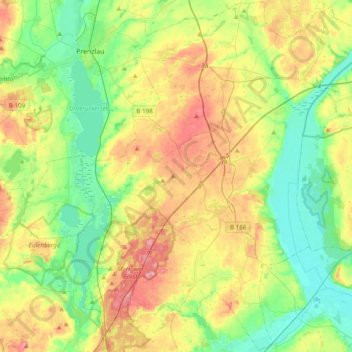
Name: Gramzow topographic map, elevation, terrain.
Location: Gramzow, Uckermark, Brandenburg, Deutschland (53.12060 13.78960 53.34901 14.17467)
Average elevation: 48 m
Minimum elevation: 5 m
Maximum elevation: 116 m
Make a donation
Other topographic maps
Click on a map to view its topography, its elevation and its terrain.
Make a donation
Make a donation
Make a donation
Cremzow
Deutschland > Brandenburg > Uckermark > Carmzow
Cremzow liegt an der Landesstraße 252 zwischen Kleptow und Weselitz. Die Bundesautobahn 20 mit der Anschlussstelle Prenzlau-Ost ist etwa fünf Kilometer entfernt. Cremzow liegt am Ufer des Großen Sees, östlich des Ortes befindet sich zudem der Höhenzug Rehberge mit einer Höhe von bis zu 66 m ü. NHN.
Average elevation: 51 m
Make a donation
Das große rote Meer
Deutschland > Brandenburg > Uckermark > Sternhagen > Hof Sternhagen
Average elevation: 43 m
Make a donation
Make a donation
Make a donation