
Make a donation
Oke Ero topographic map
Click on the map to display elevation.
Make a donation
Oke Ero
Oke ero Local Government Area is located in a region with a total area of 438 square kilometers and an average temperature of 29 degrees Celsius. The Ore and Ojokolo mountains, as well as the Are hills, are among the area's many elevations. The average wind speed in Oke Aro Local Government Area is 10 km/h, and it is located in the Tropical Savannah flora.
Make a donation
About this map
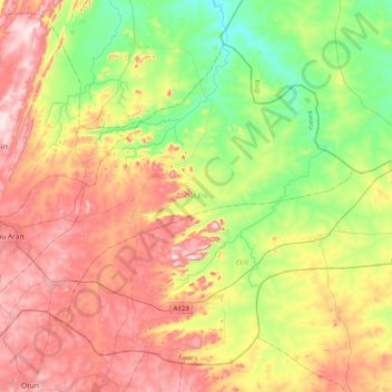
Name: Oke Ero topographic map, elevation, terrain.
Location: Oke Ero, Kwara State, Nigeria (8.02423 5.05493 8.33378 5.45753)
Average elevation: 397 m
Minimum elevation: 205 m
Maximum elevation: 633 m
Make a donation
Other topographic maps
Click on a map to view its topography, its elevation and its terrain.
Omu Aran
Nigeria > Kwara State > Irepodun
Omu Aran has a tropical wet and dry or savanna climate and is located at an elevation of 536.14 meters (1758.99 feet) above sea level (Classification: Aw). The district's average annual temperature is 0.26% higher than Nigeria's averages at 29.72°C (85.5°F). Omu Aran generally has 149.31 wet days per year…
Average elevation: 539 m
Make a donation