
Make a donation
Orange County topographic map
Click on the map to display elevation.
Make a donation
Orange County
The geography of Orange County varies relatively little, with an elevation that reaches 33 ft (10 m) above sea level at very few points within the county. Orange County is very flat, and its soil is quite sandy, as could be expected in a county along the Gulf of Mexico. (Sandy soil is also common in southern Louisiana, Mississippi, and Alabama, and in western and southern Florida.) Saltwater marshes occur in much of the southeastern part of Orange County that borders the Sabine River. The Piney Woods are in the northern part of the county.
Make a donation
About this map
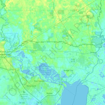
Name: Orange County topographic map, elevation, terrain.
Location: Orange County, Texas, United States (29.93956 -94.11890 30.24434 -93.68843)
Average elevation: 4 m
Minimum elevation: -6 m
Maximum elevation: 17 m
Make a donation
Other topographic maps
Click on a map to view its topography, its elevation and its terrain.
Georgetown
United States > Texas > Georgetown
The city is located on the northeastern edge of Texas Hill Country. Portions of Georgetown are located on either side of the Balcones Escarpment, a fault line in which the areas roughly east of IH-35 are flat and characterized by having black, fertile soils of the Blackland Prairie, and the west side of the…
Average elevation: 219 m
Make a donation
Padre Island National Seashore
United States > Texas > Kenedy County > Corpus Christi
Average elevation: 5 m
Make a donation
Make a donation
Sierra Blanca
United States > Texas > Hudspeth County
Sierra Blanca is found in Far West Texas, a subdivision of West Texas, and is 4,520 feet (1,380 m) above sea level. The town is part of the Trans-Pecos region within the most mountainous and arid portion of Texas. The town is located in Hudspeth County, which is large and sparsely populated. Sierra Blanca…
Average elevation: 1,391 m
Make a donation
Make a donation
Make a donation
Make a donation
Brazos Bend State Park
United States > Texas > Fort Bend County > Alvin
Brazos Bend State Park occupies land bordering the Brazos River and includes within its boundaries low-lying areas left over from the River's previous meanderings. Pre-Columbian inhabitants included a series of Native American groups, most notably the Karankawa. The land passed through a variety of landowners'…
Average elevation: 17 m
Make a donation
Make a donation
Make a donation
Make a donation
Enchanted Rock
United States > Texas > Llano County
Enchanted Rock is a pink granite mountain located in the Llano Uplift about 17 miles (27 km) north of Fredericksburg, Texas and 24 miles (39 km) south of Llano, Texas, United States. Enchanted Rock State Natural Area, which includes Enchanted Rock and surrounding land, spans the border between Gillespie and…
Average elevation: 453 m
Make a donation
Make a donation
Make a donation
Make a donation
Make a donation
Make a donation
Choke Canyon State Park - Calliham Unit
United States > Texas > McMullen County > Calliham
Average elevation: 67 m
Make a donation
Make a donation
Mineral Wells Fossil Park
United States > Texas > Palo Pinto County > Mineral Wells
Average elevation: 283 m
Make a donation
Rio Vista Addition Colonia
United States > Texas > El Paso County > Socorro
Average elevation: 1,116 m
Make a donation
Make a donation
Roy G. Guerrero Colorado River Metro Park
United States > Texas > Travis County > Austin
Average elevation: 141 m
Make a donation
Make a donation
Guadalupe Peak
United States > Texas > Culberson County
Guadalupe Peak, also known as Signal Peak, is the highest natural point in Texas, with an elevation of 8,751 feet (2,667 m) above sea level. It is located in Guadalupe Mountains National Park, and is part of the Guadalupe Mountains range in southeastern New Mexico and West Texas. The mountain is about 90 miles…
Average elevation: 2,150 m
Make a donation