
Make a donation
Saratoga County topographic map
Click on the map to display elevation.
Make a donation
Saratoga County
Saratoga County is situated in the eastern portion of New York State, north of the state capital city of Albany, northwest of Troy, and east of Utica. According to the U.S. Census Bureau, the county has a total area of 844 square miles (2,190 km2), of which 810 square miles (2,100 km2) are land and 34 square miles (88 km2) (4.0%) are covered by water. The Hudson River forms the eastern border of the county, while the Mohawk River demarcates its southern border. The highest elevation in Saratoga County is at the peak of Tennet Mountain in the Adirondack Mountains, at 2,759 ft (841 m), while the lowest elevation is 69 ft (21 m), at the waterfront of the Village of Waterford, at the confluence of the Mohawk and Hudson Rivers.
Make a donation
About this map
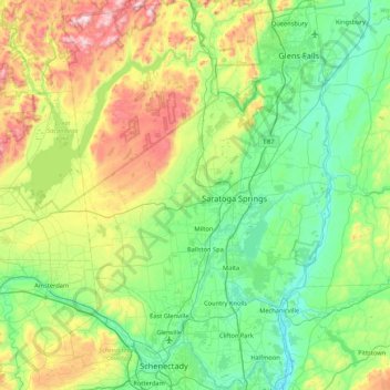
Name: Saratoga County topographic map, elevation, terrain.
Location: Saratoga County, New York, United States (42.77529 -74.16011 43.39770 -73.57332)
Average elevation: 218 m
Minimum elevation: 3 m
Maximum elevation: 833 m
Make a donation
Other topographic maps
Click on a map to view its topography, its elevation and its terrain.
Central Park
United States > New York > New York County > New York
In June 1856, Fernando Wood appointed a "consulting board" of seven people, headed by author Washington Irving, to inspire public confidence in the proposed development. Wood hired military engineer Egbert Ludovicus Viele as the park's chief engineer, tasking him with a topographical survey of the site. The…
Average elevation: 26 m
Make a donation
Make a donation
Tug Hill
United States > New York > Oswego County
The core Tug Hill region encompasses 150,000 acres (610 km2) of unbroken, generally second-growth, northern hardwood forest, and is drained by a vast network of streams. Important rivers and streams whose headwaters are located within the Tug Hill region include the Mohawk River, Deer River, Salmon River, Mad…
Average elevation: 109 m
Make a donation
Lake Peekskill
United States > New York > Putnam County > Town of Putnam Valley
Average elevation: 103 m
Make a donation
Make a donation
Whitesville
United States > New York > Allegany County > Town of Independence
Average elevation: 611 m
Hartmans Corners
United States > New York > Albany County > Town of Guilderland
Average elevation: 81 m
Make a donation
Make a donation
Pleasantside
United States > New York > Westchester County > Town of Cortlandt
Average elevation: 108 m
Make a donation
Make a donation
Make a donation
Inwood Hill Park
United States > New York > New York County > New York
Inwood Hill Park is a 196 acres (79 ha) public park in the Inwood neighborhood of Manhattan, New York City, operated by the New York City Department of Parks and Recreation. On a high schist ridge that rises 200 feet (61 m) above the Hudson River from Dyckman Street to the northern tip of the island, Inwood…
Average elevation: 14 m
Make a donation
Brooklyn Bridge Park
United States > New York > Kings County > New York
Brooklyn Bridge Park spans 85 acres (34 ha) of the East River waterfront in the Brooklyn Heights and Dumbo neighborhoods of Brooklyn. The park is divided into eleven sections: Piers 1 through 6; Fulton Ferry Landing; Brooklyn Bridge Plaza; Empire Fulton Ferry; Main Street; and John Street. Each of these…
Average elevation: 9 m
Make a donation
Catamount Mountain
United States > New York > Saint Lawrence County > Town of Colton
Average elevation: 433 m
Oscawana Corners
United States > New York > Putnam County > Town of Putnam Valley
Average elevation: 158 m
Make a donation
Make a donation
Make a donation
Woodcock Mountain
United States > New York > Saratoga County > Town of Hadley
Average elevation: 271 m
Constantia Center
United States > New York > Oswego County > Town of Constantia
Average elevation: 169 m
Make a donation
South New Berlin
United States > New York > Chenango County > Town of New Berlin
Average elevation: 380 m
Make a donation
Coney Island
United States > New York > Saint Lawrence County > Town of Pierrepont
Average elevation: 174 m
Make a donation
Make a donation
Make a donation
Make a donation
Sunset Ridge
United States > New York > Westchester County > Town/Village of Harrison
Average elevation: 27 m
Make a donation
Ellicottville
United States > New York > Cattaraugus County > Village of Ellicottville
Average elevation: 573 m
Make a donation
Make a donation
East Poestenkill
United States > New York > Rensselaer County > Town of Poestenkill
Average elevation: 376 m
Make a donation