
Borno State topographic map
Interactive map
Click on the map to display elevation.
About this map
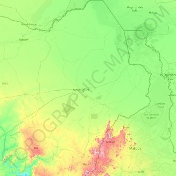
Name: Borno State topographic map, elevation, terrain.
Location: Borno State, Nigeria (10.02218 11.52934 13.72144 14.67801)
Average elevation: 360 m
Minimum elevation: 183 m
Maximum elevation: 1,330 m
Other topographic maps
Click on a map to view its topography, its elevation and its terrain.
Auchi
Nigeria > Edo State > Etsako West
The climate at Auchi, which has an elevation of 0 meters (None feet) above sea level, is tropical wet and dry or savanna (Aw classification). The district's average annual temperature is -0.74% lower than Nigeria's averages at 28.72 °C (83.7 °F). 183.14 millimeters (7.21 inches) of precipitation and 265.4…
Average elevation: 186 m
Agodi gate water corporation
Nigeria > Oyo State > Ibadan North East > Ibadan
Average elevation: 228 m
Ibadan
Nigeria > Oyo State > Ibadan South West
Ibadan, coined from the phrase "Eba-Odan", which literally means 'by the edge of the meadow', came into existence in 1829, during a period of turmoil that characterized Yorubaland at the time. It was in this period that many old Yoruba cities such as old Oyo (Oyo-ile), Ijaye and Owu disappeared, and newer ones…
Average elevation: 191 m
Abuja
Nigeria > Federal Capital Territory > Municipal Area Council
The elevation is 360 metres (1,180 ft).
Average elevation: 508 m
Abuja
Nigeria > Federal Capital Territory > Municipal Area Council
The elevation is 360 metres (1,180 ft).
Average elevation: 508 m