
Make a donation
Blekinge County topographic map
Click on the map to display elevation.
Make a donation
About this map
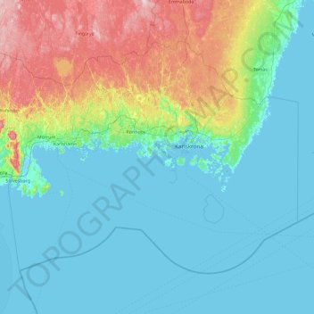
Name: Blekinge County topographic map, elevation, terrain.
Location: Blekinge County, Sweden (55.74669 14.39016 56.50351 16.22367)
Average elevation: 38 m
Minimum elevation: -3 m
Maximum elevation: 203 m
Make a donation
Other topographic maps
Click on a map to view its topography, its elevation and its terrain.
Make a donation
Make a donation
Make a donation
Make a donation
Uppsala
Situated on the fertile Uppsala flatlands of muddy soil, the city features the small Fyris River (Fyrisån) flowing through the landscape surrounded by lush vegetation. Parallel to the river runs the glacial ridge of Uppsalaåsen at an elevation around 30 m (98 ft), the site of Uppsala's castle, from which…
Average elevation: 29 m
Make a donation
Make a donation
Make a donation
Make a donation
Make a donation
Nyköping
Nyköping is the exodus of a small river named Nyköpingsån (Nyköping River), which runs through the city centre, dividing the city into a natural eastern and western part. Due to the narrowness of the river, there are a full seven crossings available for automobile traffic, one of them being for the E4. For…
Average elevation: 19 m
Make a donation