
Willey topographic map
Click on the map to display elevation.
About this map
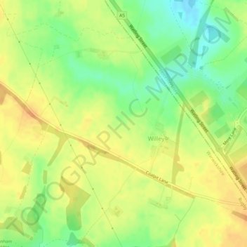
Name: Willey topographic map, elevation, terrain.
Location: Willey, Warwickshire, England, United Kingdom (52.44931 -1.29861 52.47201 -1.25293)
Average elevation: 123 m
Minimum elevation: 103 m
Maximum elevation: 136 m
Other topographic maps
Click on a map to view its topography, its elevation and its terrain.
Lye Green
United Kingdom > England > Warwickshire > Stratford-on-Avon > Claverdon
Average elevation: 106 m
Stratford-upon-Avon
United Kingdom > England > Warwickshire > Stratford-on-Avon
Average elevation: 61 m
Compton Verney CP
United Kingdom > England > Warwickshire > Stratford-on-Avon
Average elevation: 103 m
Rowington Green
United Kingdom > England > Warwickshire > Warwick > Rowington
Average elevation: 114 m
Bidford on Avon CP
United Kingdom > England > Warwickshire > Stratford-on-Avon
Average elevation: 42 m
Brook End
United Kingdom > England > Warwickshire > North Warwickshire > Hurley
Average elevation: 107 m
Stratford-on-Avon
United Kingdom > England > Warwickshire > Stratford-on-Avon
Average elevation: 108 m
Tanworth in Arden CP
United Kingdom > England > Warwickshire > Stratford-on-Avon
Average elevation: 139 m
Warwick
United Kingdom > England > Warwickshire
Warwick experiences the usual English maritime climate, marked by a narrow temperature range, mild winters and cool summers. The nearest official Met Office weather station is at Wellesbourne, about 6 miles (10 km) south of the town centre and at a similar elevation. The absolute maximum temperature (also the…
Average elevation: 87 m
Gilson
United Kingdom > England > Warwickshire > North Warwickshire > Coleshill CP
Average elevation: 82 m
Napton on the Hill
United Kingdom > England > Warwickshire > Stratford-on-Avon
Average elevation: 113 m
Hampton on the Hill
United Kingdom > England > Warwickshire > Warwick > Hampton on the Hill
Average elevation: 75 m
Bishops Itchington
United Kingdom > England > Warwickshire > Stratford-on-Avon
Average elevation: 104 m
Birmingham and Fazeley Canal
United Kingdom > England > Warwickshire > Minworth
Average elevation: 105 m
Upper Quinton
United Kingdom > England > Warwickshire > Stratford-on-Avon > Lower Quinton
Average elevation: 70 m
Stretton-on-Fosse
United Kingdom > England > Warwickshire > Stratford-on-Avon
Average elevation: 108 m
Priors Hardwick CP
United Kingdom > England > Warwickshire > Stratford-on-Avon
Average elevation: 134 m
Welford on Avon CP
United Kingdom > England > Warwickshire > Stratford-on-Avon
Average elevation: 44 m
Cranhill
United Kingdom > England > Warwickshire > Stratford-on-Avon > Ardens Grafton
Average elevation: 57 m
Curdworth Locks
United Kingdom > England > Warwickshire > North Warwickshire > Kingsbury > Curdworth CP
Average elevation: 80 m
Church End
United Kingdom > England > Warwickshire > North Warwickshire > Ansley CP
Average elevation: 151 m