
Black Sea topographic map
Interactive map
Click on the map to display elevation.
About this map
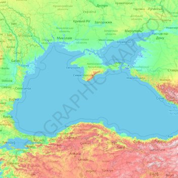
Name: Black Sea topographic map, elevation, terrain.
Location: Black Sea (40.90889 27.44261 46.90728 41.77752)
Average elevation: 322 m
Minimum elevation: -8 m
Maximum elevation: 3,363 m
Other topographic maps
Click on a map to view its topography, its elevation and its terrain.
Mobile
United States > Alabama > Mobile County
According to the United States Census Bureau, the city has a total area of 180.1 square miles (466 km2), with 139.5 square miles (361 km2) of it being land, and 40.6 square miles (105.2 km2), or 22.5% of the total, being covered by water. The elevation in Mobile ranges from 10 feet (3 m) on Water Street in…
Average elevation: 16 m
Kampala
Kampala is a hilly place with its valleys filled with sluggish rivers/ swamps. The highest point in the city proper is the summit of Kololo hill at 1,311 metres (4,301 ft), located in the center of the city and the lowest point at the shores of Lake Victoria south of the city center at altitude of 1,135 metres…
Average elevation: 1,179 m
Museum of the Imperial Palace of Manchukuo
China > Jilin > Kuancheng District
Average elevation: 208 m
Area G (Upper Similkameen/Hedley)
Canada > British Columbia > Regional District of Okanagan-Similkameen
Average elevation: 1,305 m
Lake Tahoe
United States > California > Placer County
Lake Tahoe has a dry-summer continental climate (Dsb in the Köppen climate classification), featuring warm, dry summers and chilly winters with regular snowfall. Mean annual precipitation ranges from over 55 inches (1,400 mm) for watersheds on the west side of the basin to about 26 inches (660 mm) near the…
Average elevation: 2,077 m
Crater Lake
United States > Oregon > Klamath County
The lake is 5 by 6 miles (8.0 by 9.7 km) across, with a caldera rim ranging in elevation from 7,000 to 8,000 feet (2,100 to 2,400 m) and an average lake depth of 1,148 feet (350 m). The lake's maximum depth has been measured at 1,949 feet (594 m), which fluctuates slightly as the weather changes. On the basis…
Average elevation: 1,971 m
Yass
Yass is located 280 km south-west of Sydney, on the Hume Highway, and is 59 km from Canberra. It lies at an elevation of 505 metres. The Yass River, which is a tributary of the Murrumbidgee River, flows through the town.
Average elevation: 533 m
Barrington
United States > Rhode Island > Bristol County
Barrington lies on a low, mostly flat plain bordering the sea. This plain, composed mostly of layers of clay, gravel, sand, and silt soils, was formed by a melting glacier towards the end of the last ice age. Bedrock underlying the soil is largely composed of shales, sandstone, and conglomerate rock, with some…
Average elevation: 4 m
Florida
Economic prosperity in the 1920s stimulated tourism to Florida and related development of hotels and resort communities. Combined with its sudden elevation in profile was the Florida land boom of the 1920s, which brought a brief period of intense land development. In 1925, the Seaboard Air Line broke the FEC's…
Average elevation: 6 m
Pickering
Canada > Ontario > Durham Region
The city covers an area of 231 square kilometres (89 sq mi) with an elevation of 89 metres (292 ft).
Average elevation: 170 m
Borough of Luton
The local climate around Luton is differentiated somewhat from much of South East England due to its position in the Chiltern Hills, meaning it tends to be 1–2 degrees Celsius cooler than the surrounding towns – often flights at Luton airport, lying 160 m (525 ft) above sea level, will be suspended when…
Average elevation: 146 m