

Make a donation
Pyrenees topographic map
Click on the map to display elevation.
Make a donation
Pyrenees
The Pyrenees (/ˈpɪrɪniːz/; Spanish: Pirineos [piɾiˈneos]; French: Pyrénées [piʁene] (listen); Catalan: Pirineu [piɾiˈnɛw]; Basque: Pirinioak [piɾini.o.ak]; Occitan: Pirenèus [piɾeˈnɛws]; Aragonese: Pirineus) is a mountain range straddling the border of France and Spain. It extends nearly 500 km (310 mi) from its union with the Cantabrian Mountains to Cap de Creus on the Mediterranean coast. It reaches a maximum altitude of 3,404 metres (11,168 ft) at the peak of Aneto.
Make a donation
About this map
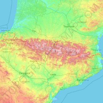
Name: Pyrenees topographic map, elevation, terrain.
Location: Pyrenees, Metropolitan France, 66120, France (42.31945 -1.79146 43.39251 3.32224)
Average elevation: 484 m
Minimum elevation: -2 m
Maximum elevation: 3,211 m
Make a donation
Other topographic maps
Click on a map to view its topography, its elevation and its terrain.
Make a donation
Vitré
France > Brittany > Ille-et-Vilaine
The land area of Vitré: 37.19 km2 (14.36 sq mi). The average altitude of Vitré is approximately 89 m. The highest point, 127 m, is found in the "Ménardières" zone, at Pierre and Marie Curie Street. The lowest point, 67 m, is close to the firm S.V.A.'s location under the viaduct of the ring-road.
Average elevation: 94 m
Make a donation
Make a donation
Make a donation
Guadeloupe
The two main islands are Basse-Terre (west) and Grande-Terre (east), which form a butterfly shape as viewed from above, the two 'wings' of which are separated by the Grand Cul-de-Sac Marin [ceb; fr; nl; sv], Rivière Salée [fr] and Petit Cul-de-Sac Marin [ceb; fr]. More than half of Guadeloupe's land surface…
Average elevation: 18 m

Make a donation
Make a donation
Aurillac
France > Auvergne-Rhône-Alpes > Cantal
Influenced by its altitude, Aurillac features an oceanic climate (Cfb), closely bordering on a warm-summer humid continental climate (Dfb) under the Köppen system. In spite of this, the city enjoys more than 2,100 hours of sunshine per year on average, but also a high amount of precipitations per year on…
Average elevation: 668 m
Make a donation
Céret
France > Occitania > Pyrénées-Orientales
The town lies in the foothills of the Pyrénées mountains, in southern France, on the river Tech at an altitude of 175–1400 meters. It is 7 km (4.3 mi) from the Autoroute A9, 200 km (120 mi) from Montpellier, 250 km (160 mi) from Toulouse and 180 km (110 mi) from Barcelona. The GR 10 footpath runs close by.
Average elevation: 454 m
Make a donation
Ax-les-Thermes
Ax (from Latin Aquae – water; French Thermes – hot springs), situated at an elevation of 700 metres (2,300 ft), is well known for its sulphurous hot springs (25 to 78 °C or 77 to 172 °F). The waters, which were used by the Romans, were historically claimed to treat rheumatism, skin diseases, and other…
Average elevation: 1,449 m
Make a donation
Pau
France > Nouvelle-Aquitaine > Pyrénées-Atlantiques
The city, located at an average altitude of 200 metres (660 ft), is crossed by the Gave de Pau, where a ford gave passage to the Pyrenees. Gave is the name given to a torrent in the Pyrenees. The Gave de Pau, which becomes a torrent when mountain snow melts, takes its source in the Cirque de Gavarnie and is…
Average elevation: 205 m
Annecy
France > Auvergne-Rhône-Alpes > Upper Savoy
Annecy has an oceanic climate (Köppen: Cfb) despite its relatively far inland position. Influenced by its elevation, summers are rather moderate on average, although they can be highly variable with extreme heat spikes. Winters see occasional freezing temperatures, but temperatures most often stay in the…
Average elevation: 610 m
Make a donation
Make a donation
Make a donation
Make a donation
Make a donation
Ribérac
France > Nouvelle-Aquitaine > Dordogne
Ribérac is on the left bank of the Dronne. To the north, the soil in the Dronne valley is covered with alluvium, while the heights are made up of Cretaceous limestones. Its minimum altitude, 54 meters, is located in the extreme north-west of the town, where a small arm of the Dronne leaves the town.
Average elevation: 107 m
Make a donation
Ussel
France > Nouvelle-Aquitaine > Corrèze
The community of Ussel is located in the Massif central on the foothills of the plateau de Millevaches. The city itself sits on a hilltop in between the valley of the river Diège and the valley of the river Sarsonne. It is situated at an altitude of 2070 ft (631 m), in the Massif Central on the last buttress…
Average elevation: 680 m
Make a donation
La Bachellerie-du-Nord
France > Nouvelle-Aquitaine > Haute-Vienne > Saint-Yrieix-la-Perche
Average elevation: 386 m
Make a donation

Angoulême
France > Nouvelle-Aquitaine > Charente
The earliest Cretaceous period - the Cenomanian- is in the relatively low areas (l'Houmeau, the heights of Saint-Cybard, Sillac), at an average altitude of 50m.
Average elevation: 72 m

Marennes
France > Nouvelle-Aquitaine > Charente-Maritime > Marennes-Hiers-Brouage
Average elevation: 4 m
Make a donation
Make a donation
Make a donation
Make a donation

Chinon
France > Centre-Val de Loire > Indre-et-Loire
Topography has played a major role: the formerly fortified town was developed at the foot of the castle on the rocky outcrop, protecting the northern side, with the Vienne River in the south. Apart from the natural defensive protection on both sides, this fact makes a long narrow urban space, with the main…
Average elevation: 58 m
Make a donation
Orléans
France > Centre-Val de Loire > Loiret
At the end of the 1960s, the Orléans-la-Source [fr] neighbourhood was created, 12 kilometres (7 mi)to the south of the original commune and separated from it by the Val d'Orléans and the river Loiret (whose source is in the Parc Floral de la Source). This quarter's altitude varies from about 100 to 110 m…
Average elevation: 104 m
Make a donation

Make a donation

Make a donation