
Augusta County topographic map
Interactive map
Click on the map to display elevation.
About this map
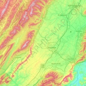
Name: Augusta County topographic map, elevation, terrain.
Location: Augusta County, Virginia, USA (37.88586 -79.53362 38.48059 -78.75125)
Average elevation: 570 m
Minimum elevation: 176 m
Maximum elevation: 1,342 m
Other topographic maps
Click on a map to view its topography, its elevation and its terrain.
Mechanicsville
USA > Virginia > Mechanicsville
Mechanicsville, Hanover County, Virginia, USA
Average elevation: 50 m
Elletts Crossing
USA > Virginia > Elletts Crossing
Elletts Crossing, Hanover County, Virginia, 23047, USA
Average elevation: 45 m
James River
James River, Henrico County, Virginia, 23219:23223, USA
Average elevation: 89 m