
Albemarle County topographic map
Interactive map
Click on the map to display elevation.
About this map
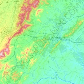
Name: Albemarle County topographic map, elevation, terrain.
Location: Albemarle County, Virginia, USA (37.72855 -78.83935 38.27782 -78.20789)
Average elevation: 259 m
Minimum elevation: 68 m
Maximum elevation: 1,156 m
Other topographic maps
Click on a map to view its topography, its elevation and its terrain.
Mechanicsville
USA > Virginia > Mechanicsville
Mechanicsville, Hanover County, Virginia, USA
Average elevation: 50 m
Elletts Crossing
USA > Virginia > Elletts Crossing
Elletts Crossing, Hanover County, Virginia, 23047, USA
Average elevation: 45 m
James River
James River, Henrico County, Virginia, 23219:23223, USA
Average elevation: 89 m