Kosofe topographic map
Interactive map
Click on the map to display elevation.
About this map
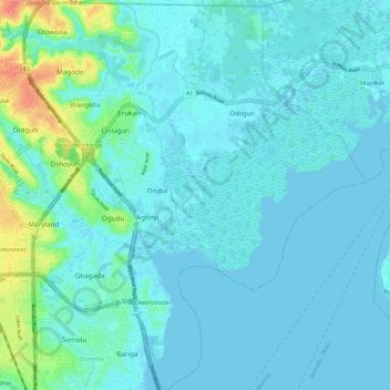
Name: Kosofe topographic map, elevation, terrain.
Location: Kosofe, Lagos, 100234, Nigeria (6.52420 3.36415 6.63904 3.46551)
Average elevation: 7 m
Minimum elevation: -6 m
Maximum elevation: 49 m
Other topographic maps
Click on a map to view its topography, its elevation and its terrain.
Ajegunle
Nigeria > Lagos > Ajeromi/Ifelodun > Ajegunle
Ajegunle, Ajeromi/Ifelodun, Lagos, 101212, Nigeria
Average elevation: 5 m
Ajegunle
Nigeria > Lagos > Ifako/Ijaye > Ajegunle
Ajegunle, Ifako/Ijaye, Lagos, 2340, Nigeria
Average elevation: 53 m
Ajegunle Canal
Nigeria > Lagos > Surulere > Osho
Ajegunle Canal, Osho, Surulere, Lagos, 101212, Nigeria
Average elevation: 4 m
Victoria Island
Victoria Island, Apese, Eti Osa, Lagos, 71510, Nigeria
Average elevation: 10 m
Ibese
Nigeria > Lagos > Amuwo Odofin > Ibese
Ibese, Amuwo Odofin, Lagos, Nigeria
Average elevation: 2 m
Iddo Island
Iddo Island, Lagos Mainland, Lagos, 101001, Nigeria
Average elevation: 13 m
Tarkwa Bay
Nigeria > Lagos > Tarkwa Bay
Tarkwa Bay, Amuwo Odofin, Lagos, 71510, Nigeria
Average elevation: 1 m