
Tigray topographic map
Interactive map
Click on the map to display elevation.
Tigray
Of the 10 largest cities in Tigray, Maychew has the highest elevation at 2479 meter above sealevel. Plenty of smaller towns, like Atsbi and Edaga Hamus are located at even higher elevations. Of the large cities, Humera is located at the lowest altitude (585 m).
About this map
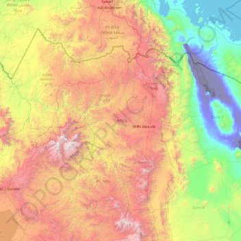
Name: Tigray topographic map, elevation, terrain.
Location: Tigray, Ethiopia (12.25628 36.44639 14.89434 39.99175)
Average elevation: 1,346 m
Minimum elevation: -126 m
Maximum elevation: 4,418 m
Other topographic maps
Click on a map to view its topography, its elevation and its terrain.
Mojo
Mojo (Oromo: Moojoo, Amharic: ሞጆ) is a town in central Ethiopia, named after the nearby Modjo River. Located in the East Shewa Zone of the Oromia Region, it has a latitude and longitude of 8°39′N 39°5′E / 8.650°N 39.083°E / 8.650; 39.083 with an elevation between 1788 and 1825 meters above…
Average elevation: 1,800 m
Ethiopia
In 2019, archaeologists discovered a 30,000-year-old Middle-Stone Age rock shelter at the Fincha Habera site in the Bale Mountains of Ethiopia at an elevation of 3,469 metres above sea level. At this high altitude humans are susceptible both to hypoxia and to extreme weather. According to a study published in…
Average elevation: 846 m