
Grafton County topographic map
Interactive map
Click on the map to display elevation.
About this map
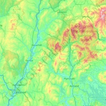
Name: Grafton County topographic map, elevation, terrain.
Location: Grafton County, New Hampshire, USA (43.52812 -72.33517 44.40665 -71.34686)
Average elevation: 424 m
Minimum elevation: 94 m
Maximum elevation: 1,902 m
Other topographic maps
Click on a map to view its topography, its elevation and its terrain.
Plaistow
USA > New Hampshire > Plaistow
Plaistow, Rockingham County, New Hampshire, 03865, USA
Average elevation: 37 m
Charlestown
USA > New Hampshire > Charlestown
Charlestown, Sullivan County, New Hampshire, 03603, USA
Average elevation: 256 m
Mount Washington
USA > New Hampshire > Sargent's Purchase
Mount Washington, Sargent's Purchase, Coös County, New Hampshire, USA
Average elevation: 1,568 m
Meredith
USA > New Hampshire > Meredith
Meredith, Belknap County, New Hampshire, 03253, USA
Average elevation: 215 m