
Make a donation
Poland topographic map
Click on the map to display elevation.
Make a donation
Poland
Poland's topography is characterized by a diverse landscape that transitions from the Baltic Sea's sandy beaches in the north to mountainous regions in the south. The northern coastline features sand dunes and is indented by spits and lagoons, such as the Hel Peninsula and the Vistula Lagoon. Moving inland, the terrain is shaped by glacial activity, resulting in numerous lakes and gentle hills, particularly evident in the Masurian Lake District, which boasts over 2,000 lakes amidst dense forests. Central Poland is dominated by the expansive Polish Plain, a flat region crisscrossed by major rivers like the Vistula and the Oder, making it ideal for agriculture. Further south, the landscape becomes more varied with uplands and highlands, including the Lesser Poland Uplands, characterized by rolling hills and fertile valleys. The southernmost part of the country is marked by the Sudeten and Carpathian mountain ranges. The Carpathians encompass the Tatra Mountains, where Poland's highest peak, Mount Rysy, reaches 2,501 meters (8,205 feet). This diverse terrain supports a rich array of ecosystems and contributes to Poland's varied climate patterns.
Make a donation
About this map
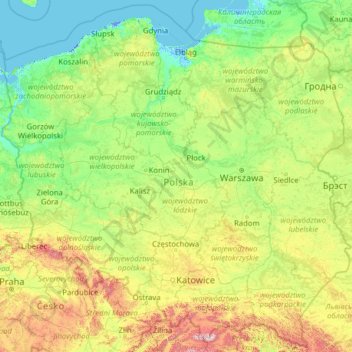
Name: Poland topographic map, elevation, terrain.
Location: Poland (49.00205 14.06964 55.03605 24.14578)
Average elevation: 194 m
Minimum elevation: -6 m
Maximum elevation: 2,237 m
Make a donation
Other topographic maps
Click on a map to view its topography, its elevation and its terrain.
Make a donation
Make a donation
At Ta'if
Taif (Arabic: اَلطَّائِفُ, romanized: Aṭ-Ṭāʾif, lit. 'The circulated or encircled', Hejazi Arabic pronunciation: [atˤˈ tˤaː(j)ɪf]) is a city and governorate in Mecca Province in Saudi Arabia. Located at an elevation of 1,879 m (6,165 ft) in the slopes of the Hijaz Mountains, which…
Average elevation: 1,742 m
Make a donation
Make a donation
Dinaric Alps
Bosnia and Herzegovina > Federation of Bosnia and Herzegovina > City of Livno
Average elevation: 1,599 m
Make a donation
Junma Sichang Qilian
China > Gansu > Shandan County > Shandan horse breeding area
Average elevation: 2,558 m
Ivel Springs Local Nature Reserve
United Kingdom > England > Hertfordshire > North Hertfordshire > Baldock
Average elevation: 72 m
Make a donation
Make a donation
Make a donation
Islamabad
Pakistan > Islamabad Capital Territory
Islamabad's micro-climate is regulated by three artificial reservoirs: Rawal, Simli, and Khanpur Dam. The latter is located on the Haro River near the town of Khanpur, about 40 kilometres (25 mi) from Islamabad. Simli Dam is 30 kilometres (19 mi) north of Islamabad. 220 acres (89 ha) of the city consists of…
Average elevation: 666 m
Make a donation
Kopaonik
Serbia > Rasina Administrative District > Brus Municipality
Kopaonik (Serbian Cyrillic: Копаоник; Albanian: Kopaoniku) is a mountain range located in Kosovo and Serbia. The highest point of this mountain range is the Pančić's Peak with an altitude of 2,017 m (6,617 ft). The central part of the Kopaonik plateau was declared a national park in 1981 which today…
Average elevation: 1,733 m
Make a donation
Mapusa
Mapusa is located at 15°36′N 73°49′E / 15.60°N 73.82°E / 15.60; 73.82. It has an average elevation of 15 metres (49 feet). It lies on the banks of Mapusa River. Mapusa has a tropical climate with temperatures ranging from a high of 37 °C in summer with high levels of humidity to a low of 21 °C in winters.
Average elevation: 26 m
Make a donation
Croce di Envie - Cima Bracco
Italy > Piedmont > Cuneo > Sanfront
The Monte Bracco (though the name is sometimes shortened to Mombracco) is a mountain in the Cottian Alps with an elevation of 1,307 meters above sea level. It is located between the Valle Po, the Valle Infernotto [it], and the Cuneo plain.
Average elevation: 947 m
Make a donation
Make a donation
Make a donation
Little Current
Canada > Ontario > Manitoulin District > Northeastern Manitoulin and the Islands
Average elevation: 193 m
Make a donation
Make a donation
Make a donation
Make a donation
Buurhakaba
Somalia > Bay > Burhakaba District
Burhakaba is situated at the coordinates of 2.7991° N, 44.0794° E with an elevation of 196 meters above sea level. It lacks a permanent river, but it does have a large valley known as "Bohol Wiinti" that runs through the town from the north, east, and south-east. After seasonal rainfall, the valley supports…
Average elevation: 203 m
Make a donation
Aalborg
Denmark > North Denmark Region
The area close to the waterfront is low-lying, with an elevation averaging about 5 metres (16 ft), but there are many hills in and around city, some reaching over 60 m (200 ft). Nørresundby, on the northern side of the sound, is also a hilly area. Villages to the south of Aalborg from west to east include…
Average elevation: 17 m
Make a donation
Make a donation
Make a donation
Abuja
Nigeria > Federal Capital Territory > Municipal Area Council
The elevation is 360 metres (1,180 ft).
Average elevation: 508 m
Make a donation
Mbeya
Mbeya is situated at an altitude of 1,700 metres (5,500 ft), and sprawls through a narrow highland valley surrounded by a bowl of high mountains. The main language is colloquial Swahili, and the English language is extensively taught in schools.
Average elevation: 1,817 m
Make a donation
Derry/Londonderry
United Kingdom > Northern Ireland > County Londonderry
Derry is characterised by its distinctively hilly topography. The River Foyle forms a deep valley as it flows through the city, giving it a steep topography. The original walled city of Londonderry lies on a hill on the west bank of the River Foyle. In the past, the river branched and enclosed this hill as an…
Average elevation: 88 m
Make a donation