
Thank you for supporting this site ❤️
Make a donation
Make a donation
Imeko Afon topographic map
Click on the map to display elevation.
Thank you for supporting this site ❤️
Make a donation
Make a donation
About this map
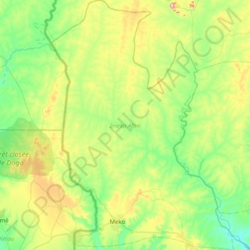
Name: Imeko Afon topographic map, elevation, terrain.
Location: Imeko Afon, Ogun State, Nigeria (7.38505 2.69052 7.95286 3.11030)
Average elevation: 178 m
Minimum elevation: 60 m
Maximum elevation: 498 m
Thank you for supporting this site ❤️
Make a donation
Make a donation
Other topographic maps
Click on a map to view its topography, its elevation and its terrain.
Thank you for supporting this site ❤️
Make a donation
Make a donation
Thank you for supporting this site ❤️
Make a donation
Make a donation